1940s Maps of Thomson, Georgia
Explore 2 historic maps of Thomson from the 1940s. These maps offer a rare glimpse into what life looked like during the 1940s — showing old roads, neighborhoods, homes, and landmarks that have changed or disappeared over time.
Whether you're researching your family's past, planning a metal detecting trip, or studying how Thomson's landscape evolved across the 1940s, these high-resolution maps are a powerful tool for exploring the history of this region.
- Focus on a specific era: All maps on this page are from the 1940s, giving you a focused view of this time period.
- See what’s changed: Compare century-old streets, trails, and buildings to today's modern landscape using overlays and satellite layers.
- Research with precision: Use these maps for genealogy, historical research, land use analysis, or educational projects.
- View, download, or print: Maps are fully viewable online in high resolution, and can be downloaded or printed for your own records.
Start exploring Thomson's history through authentic maps from the 1940s. This is your window into the past.
Thomson, GA maps
(2)- 1948 Map of Harlem
 1948 Harlem1948 Print · USGSEastern Georgia in the late forties shows the expansion of the Camp Gordon Military Reservation into a landscape of rural hamlets. Researchers can trace old family sites like Bynum Cemetery and vanished landmarks like Central School (Abandoned).2 unique versions available
 - 1948 Map of Thomson East, 1981 Print
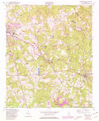 1948 Thomson East1981 Print · USGSEastern McDuffie County was a landscape of rail-connected towns and deeply rooted family homesteads at the mid-century mark. Researchers can trace ancestral sites like the Watson Family Cemetery and community hubs like St Luke Church and School or the stop at Boneville.
End of results
Showing maps 1-2 of 2
Top cities near Thomson
- Augusta historical maps
- Harlem historical maps
- Warrenton historical maps
- Appling historical maps
- Gibson historical maps
- Dearing historical maps
See more
Frequently asked questions
- What are the different types of historical maps available for Thomson?
- What is the oldest map of Thomson?
- Where can I purchase historical maps of Thomson for my home or office?
- Where can I download high-res historical maps of Thomson?
- Are there historical topographic maps available for Thomson?
- Is there historical aerial imagery available for Thomson?
- Where are historical maps of Thomson sourced from?