
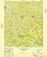
1948 Map of Harlem
USGS Topo · Published 1948About this map
Harlem and Dearing serve as central hubs for this 1940s landscape, positioned along the Georgia railroad line that cuts through the northern portion of the region. The map captures a moment of transition as the Camp Gordon Military Reservation occupies a massive swath of territory south of Berzelia and Campania. This military footprint sits in contrast to the rural agricultural character found elsewhere, marked by family-named landmarks like Larkins Cemetery and Ivory Family Cemetery.
Find a feature on this map
99 named features on this map. Tap any name to fly to it.
Don’t see what you’re looking for? This feature index may not catch every label — zoom into the map to look around manually.
Map Details
Editions of this 1948 Harlem Map
2 editions found
Other maps of this area

1892 · Mc Cormick
USGS Topo · 1:125,000

1906 · Crawfordville
USGS Topo · 1:125,000

1912 · Mc Cormick
USGS Topo · 1:125,000

1919 · Gough
USGS Topo · 1:62,500

1920 · Stapleton
USGS Topo · 1:62,500

1920 · Clarks Hill
USGS Topo · 1:48,000

1921 · Clarks Hill
USGS Topo · 1:62,500
1921 · Appling
USGS Topo · 1:62,500

1922 · Harlem
USGS Topo · 1:62,500

1922 · Hephzibah
USGS Topo · 1:62,500