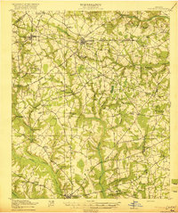
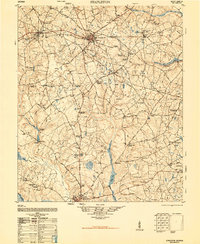
1920 Map of Stapleton
USGS Topo · Published 1920About this map
Stapleton and Wrens serve as central nodes for a sprawling agricultural landscape at the close of the 1910s, defined by a dense network of early thoroughfares like Quaker Road and the Augusta and Savannah Road. The region is marked by its numerous rural institutions, including Harts Grove Church and Tuckahoe School, which anchored the small farming communities of eastern Georgia. The Southern Ry provides the primary industrial link, passing through Wrens Sta and Matthews, while smaller settlements like Zebina and Stellaville are connected by numerous bridges over the winding Duhart Creek and Rocky Creek. A distinct patterns of water-driven industry is evident at Kings Millpond and Clarks Mill, illustrating how the local economy utilized the drainage basins of the Ogeechee R before the era of modern paved highways.
Find a feature on this map
72 named features on this map. Tap any name to fly to it.
Don’t see what you’re looking for? This feature index may not catch every label — zoom into the map to look around manually.
Map Details
Editions of this 1920 Stapleton Map
3 editions found