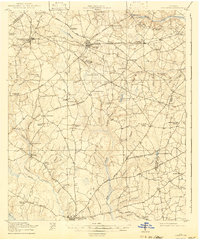
1920 Map of Stapleton
USGS Topo · Published 1942About this map
The agricultural landscape of Jefferson and Burke counties is dominated by a complex network of schools and churches, reflecting the rural community structure during the early 20th century. Major hubs like Wrens and Stapleton serve as centers of activity along the Southern railroad line, while smaller settlements such as Stellaville and Zebina dot the countryside. The geography is defined by numerous watercourses, including Brushy Creek and Duhart Creek, which supported early industry at sites like Clarks Mill and Kings Millponds.
Find a feature on this map
79 named features on this map. Tap any name to fly to it.
Don’t see what you’re looking for? This feature index may not catch every label — zoom into the map to look around manually.
Map Details
Editions of this 1920 Stapleton Map
3 editions found
Other maps of this area

1919 · Gough
USGS Topo · 1:62,500

1920 · Stapleton
USGS Topo · 1:62,500

1922 · Harlem
USGS Topo · 1:62,500

1922 · Hephzibah
USGS Topo · 1:62,500

1948 · Hephzibah
USGS Topo · 1:62,500

1948 · Harlem
USGS Topo · 1:62,500

1948 · Stapleton
USGS Topo · 1:62,500

1948 · Gough
USGS Topo · 1:62,500

1948 · Blythe
USGS Topo · 1:24,000

1948 · Louisville
USGS Topo · 1:24,000