
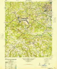
1948 Map of Hephzibah
USGS Topo · Published 1948About this map
Augusta and its southern environs appear here at a time of post-war military expansion and agricultural tradition. The landscape is dominated by the sprawling Camp Gordon Military Reservation, which occupies a significant portion of the western territory, while the Augusta Arsenal and Daniel Field underscore the city's strategic importance during the late 1940s. Beyond the military zones, the map reveals a deeply rooted rural community defined by family-named landmarks and local industry, such as the Albion-Kaolin Chalk Mine near Hephzibah.
Find a feature on this map
142 named features on this map. Tap any name to fly to it.
Don’t see what you’re looking for? This feature index may not catch every label — zoom into the map to look around manually.
Map Details
Editions of this 1948 Hephzibah Map
2 editions found
Other maps of this area

1892 · Mc Cormick
USGS Topo · 1:125,000

1912 · Mc Cormick
USGS Topo · 1:125,000

1919 · Gough
USGS Topo · 1:62,500

1920 · Stapleton
USGS Topo · 1:62,500

1920 · Greens Cut
USGS Topo · 1:62,500

1920 · Clarks Hill
USGS Topo · 1:48,000

1921 · Augusta
USGS Topo · 1:62,500

1921 · Clarks Hill
USGS Topo · 1:62,500

1921 · Appling
USGS Topo · 1:62,500

1922 · Harlem
USGS Topo · 1:62,500