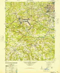
1948 Map of Hephzibah
USGS Topo · Published 1948About this map
The Augusta outskirts and the sprawling Camp Gordon Military Reservation dominate this post-war landscape, revealing a region defined by institutional growth and rural endurance. North of the reservation, the Augusta Arsenal and Daniel Field mark the city's military and aviation footprint, while the Georgia Railroad threads through settlements like Belair and Wheless. The map captures an era of social transition, evidenced by the Georgia Training School Farm and the Woods Chapel School (Abandoned). Further south, the terrain transitions into a patchwork of family-named water bodies and rural congregations. Economic life is anchored by the Albion Kaolin Chalk Mine near Hephzibah, a reminder of the local clay industry. Numerous country churches and cemeteries, such as the Spring Grove Church and Cemetery and Franklin Covenant Church, provide essential points of reference for genealogists tracing family roots in Richmond County.
Find a feature on this map
97 named features on this map. Tap any name to fly to it.
Don’t see what you’re looking for? This feature index may not catch every label — zoom into the map to look around manually.
Map Details
Editions of this 1948 Hephzibah Map
2 editions found

Other maps of this area

1892 · Mc Cormick
USGS Topo · 1:125,000

1912 · Mc Cormick
USGS Topo · 1:125,000

1919 · Gough
USGS Topo · 1:62,500

1920 · Stapleton
USGS Topo · 1:62,500

1920 · Greens Cut
USGS Topo · 1:62,500

1920 · Clarks Hill
USGS Topo · 1:48,000

1921 · Augusta
USGS Topo · 1:62,500

1921 · Clarks Hill
USGS Topo · 1:62,500

1921 · Appling
USGS Topo · 1:62,500

1922 · Harlem
USGS Topo · 1:62,500