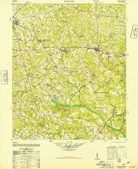
1948 Map of Harlem
USGS Topo · Published 1948About this map
The Georgia Railroad serves as the central spine of this 1948 survey, connecting the rural communities of Thomson, Dearing, and Harlem. This landscape is defined by its transition from small-scale agricultural holdings to large-scale military installation, with the eastern portion dominated by the Camp Gordon Military Reservation. The map provides a detailed record of the region’s social infrastructure just after World War II, showing numerous combined institutions like the St Luke Church and School and Foster Head Church and School. Water-powered industry and local hydrology are evident along Brier Creek and Reedy Creek, including the Nortons Mill Race and Norton Mill Pond. Scattered family names are preserved through landmarks such as Walker Cemetery, Bynum Cemetery, and Shields Pond, documenting a settled rural landscape before modern development and expansion altered the character of Columbia and McDuffie counties.
Find a feature on this map
108 named features on this map. Tap any name to fly to it.
Don’t see what you’re looking for? This feature index may not catch every label — zoom into the map to look around manually.
Map Details
Editions of this 1948 Harlem Map
2 editions found

Other maps of this area

1892 · Mc Cormick
USGS Topo · 1:125,000

1906 · Crawfordville
USGS Topo · 1:125,000

1912 · Mc Cormick
USGS Topo · 1:125,000

1919 · Gough
USGS Topo · 1:62,500

1920 · Stapleton
USGS Topo · 1:62,500

1920 · Clarks Hill
USGS Topo · 1:48,000

1921 · Clarks Hill
USGS Topo · 1:62,500

1921 · Appling
USGS Topo · 1:62,500

1922 · Harlem
USGS Topo · 1:62,500

1922 · Hephzibah
USGS Topo · 1:62,500