1900s (20th Century) Maps of Shellman Bluff, Georgia
Explore 11 historic maps of Shellman Bluff from the 1900s (20th Century). These maps offer a rare glimpse into what life looked like during the 1900s — showing old roads, neighborhoods, homes, and landmarks that have changed or disappeared over time.
Whether you're researching your family's past, planning a metal detecting trip, or studying how Shellman Bluff's landscape evolved across the 1900s, these high-resolution maps are a powerful tool for exploring the history of this region.
- Focus on a specific era: All maps on this page are from the 1900s, giving you a focused view of this time period.
- See what’s changed: Compare century-old streets, trails, and buildings to today's modern landscape using overlays and satellite layers.
- Research with precision: Use these maps for genealogy, historical research, land use analysis, or educational projects.
- View, download, or print: Maps are fully viewable online in high resolution, and can be downloaded or printed for your own records.
Start exploring Shellman Bluff's history through authentic maps from the 1900s. This is your window into the past.
Shellman Bluff, GA maps
(11)- 1920 Map of Sapelo River
 1920 Sapelo River1920 Print · USGSCoastal McIntosh and Liberty counties were a network of tidal rivers and timber-line railroads during the early twentieth century. Genealogists and historians can trace rail stops like Brewsters Siding, the winding course of the Julienton River, and the landing at Sutherland Bluff.
 - 1943 Map of Sapelo River, 1964 Print
 1943 Sapelo River1964 Print · USGSCoastal McIntosh and Liberty counties appear here during the mid-century, defined by a labyrinth of tidal waterways and remote island settlements. Researchers can trace the legacy of old rail stops and road junctions like Warsaw, Brewsters Siding, and Eulonia Station.
 - 1945 Map of Sapelo River
 1945 Sapelo River1945 Print · USGSCoastal Georgia in the mid-1940s reveals a landscape of tidal rivers and strategic military outposts. Genealogists and historians can trace rail-side settlements like Brewsters Siding and Eulonia Station or locate the Harris Neck Bombing Range and Crescent Station PO.
 - 1946 Map of Brunswick, 1948 Print
 1946 Brunswick1948 Print · USGSCoastal Georgia in the mid-forties reveals a landscape defined by the Camp Stewart Military Reservation and the sprawling barrier islands. Genealogists and historians can trace the rail-and-river network through inland towns like Ludowici and Jesup, or locate coastal landmarks like the St Simon Light.
 - 1948 Map of Brunswick
 1948 Brunswick1948 Print · USGSCoastal Georgia in the late 1940s is defined here by its labyrinthine barrier islands and the massive footprint of Camp Stewart. Genealogists and historians can trace the rail-tied growth of Jesup and Hinesville or locate coastal landmarks like St Simon Light.
 - 1954 Map of Shellman Bluff, 1959 Print
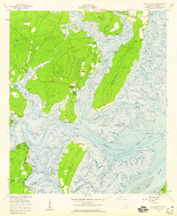 1954 Shellman Bluff1959 Print · USGSMcIntosh County’s intricate coastline is preserved here in the mid-fifties, showing the tidal rivers and fishing bluffs of the Georgia Lowcountry. Genealogists and historians can trace family-named sites like Shellman Bluff, rural centers like Crescent, and several Artesian Wells.2 unique versions available
 - 1956 Map of Brunswick, 1968 Print
 1956 Brunswick1968 Print · USGSThe Georgia coast in the mid-twentieth century is a wild expanse of barrier islands and massive river deltas. You can trace the development of the maritime economy and military presence at Brunswick, or locate historic sites like Fort Frederica National Monument and Harris Neck National Wildlife Refuge.2 unique versions available
 - 1961 Map of Brunswick
 1961 Brunswick1961 Print · USGSThe Georgia coast at the start of the 1960s was a landscape of deep tidal marshes and growing military installations. Genealogists and historians can trace rail-linked towns like Limerick Station or explore coastal landmarks from Fort Frederica National Monument to Sapelo Island.
 - 1978 Map of Brunswick
 1978 Brunswick1978 Print · USGSThe Georgia coast and its barrier islands are captured in the late 1970s, as I-95 and the rail lines shaped the growth of coastal towns. Genealogists and historians can trace family locations across the islands or locate sites near Fort Stewart, Darien, and Ludowici.2 unique versions available
 - 1979 Map of Shellman Bluff
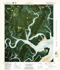 1979 Shellman Bluff1979 Print · USGSThe McIntosh County coast in the late 1970s reveals a world of tidal rivers and historic riverside bluffs. Researchers can trace the layout of Contentment Plantation, the roads into Shellman Bluff, and landmarks like Sutherland Bluff.2 unique versions available
 - 1981 Map of Jesup, 1982 Print
 1981 Jesup1982 Print · USGSCoastal Georgia in the early eighties shows a landscape of expansive river deltas and military reservations stretching from the interior to the Atlantic. Genealogists and local historians can trace family locations near Jesup, the old port of Sunbury, or the tidal reaches of the Altamaha River.
End of results
Showing maps 1-11 of 11
Top cities near Shellman Bluff
Frequently asked questions
- What are the different types of historical maps available for Shellman Bluff?
- What is the oldest map of Shellman Bluff?
- Where can I purchase historical maps of Shellman Bluff for my home or office?
- Where can I download high-res historical maps of Shellman Bluff?
- Are there historical topographic maps available for Shellman Bluff?
- Is there historical aerial imagery available for Shellman Bluff?
- Where are historical maps of Shellman Bluff sourced from?