1960s Maps of Saint Marks, Georgia
Explore 2 historic maps of Saint Marks from the 1960s. These maps offer a rare glimpse into what life looked like during the 1960s — showing old roads, neighborhoods, homes, and landmarks that have changed or disappeared over time.
Whether you're researching your family's past, planning a metal detecting trip, or studying how Saint Marks's landscape evolved across the 1960s, these high-resolution maps are a powerful tool for exploring the history of this region.
- Focus on a specific era: All maps on this page are from the 1960s, giving you a focused view of this time period.
- See what’s changed: Compare century-old streets, trails, and buildings to today's modern landscape using overlays and satellite layers.
- Research with precision: Use these maps for genealogy, historical research, land use analysis, or educational projects.
- View, download, or print: Maps are fully viewable online in high resolution, and can be downloaded or printed for your own records.
Start exploring Saint Marks's history through authentic maps from the 1960s. This is your window into the past.
Saint Marks, GA maps
(2)- 1964 Map of Grantville, 1966 Print
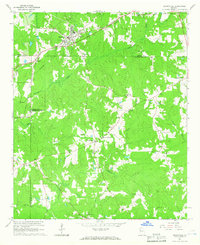 1964 Grantville1966 Print · USGSWest-central Georgia at the height of the sixties is documented here as the railroad corridor connects rural communities across three counties. Genealogists can trace family names at Holly Springs Cem or locate the High Sch and St Pauls Ch in the Lone Oak area.3 unique versions available
 - 1964 Map of Odessadale, 1966 Print
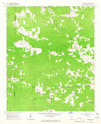 1964 Odessadale1966 Print · USGSThe border of Troup and Meriwether counties comes into focus in the mid-1960s, showing a rural landscape of family cemeteries and wooded creek branches. Trace local history through Saint Marks Ch, the OLD RAILROAD GRADE, and numerous family plots like McLaughlin Cem and Cousins Cem.
End of results
Showing maps 1-2 of 2
Top cities near Saint Marks
- Newnan historical maps
- Peachtree City historical maps
- LaGrange historical maps
- Grantville historical maps
- Hogansville historical maps
- Greenville historical maps
See more
Frequently asked questions
- What are the different types of historical maps available for Saint Marks?
- What is the oldest map of Saint Marks?
- Where can I purchase historical maps of Saint Marks for my home or office?
- Where can I download high-res historical maps of Saint Marks?
- Are there historical topographic maps available for Saint Marks?
- Is there historical aerial imagery available for Saint Marks?
- Where are historical maps of Saint Marks sourced from?