1970s Maps of Oconee County, Georgia
Explore 2 historic maps of Oconee County from the 1970s. These maps offer a rare glimpse into what life looked like during the 1970s — showing old roads, neighborhoods, homes, and landmarks that have changed or disappeared over time.
Whether you're researching your family's past, planning a metal detecting trip, or studying how Oconee County's landscape evolved across the 1970s, these high-resolution maps are a powerful tool for exploring the history of this region.
- Focus on a specific era: All maps on this page are from the 1970s, giving you a focused view of this time period.
- See what’s changed: Compare century-old streets, trails, and buildings to today's modern landscape using overlays and satellite layers.
- Research with precision: Use these maps for genealogy, historical research, land use analysis, or educational projects.
- View, download, or print: Maps are fully viewable online in high resolution, and can be downloaded or printed for your own records.
Start exploring Oconee County's history through authentic maps from the 1970s. This is your window into the past.
Oconee County, GA maps
(2)- 1972 Map of Apalachee, 1974 Print
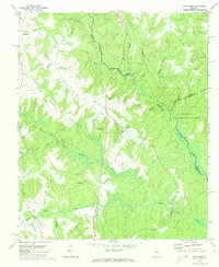 1972 Apalachee1974 Print · USGSMorgan County and its neighbors are captured here in the early 1970s, showcasing a rural landscape defined by the Apalachee River and small rail-side towns. Genealogists can trace family landmarks like Malloy Chapel, Flat Rock Ch, and the local Cem sites found near Bostwick.2 unique versions available
 - 1972 Map of Greshamville, 1974 Print
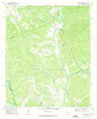 1972 Greshamville1974 Print · USGSGreene County is captured in the early 1970s, showcasing a landscape defined by the Oconee River and forest land. Genealogists can locate rural landmarks like New Hope Ch, Fork Chapel, and the historic site at Scull Shoals Historic Area.2 unique versions available
End of results
Showing maps 1-2 of 2
Top cities of Oconee County
- Watkinsville historical maps
- Bogart historical maps
- North High Shoals historical maps
- Bishop historical maps
Frequently asked questions
- What are the different types of historical maps available for Oconee County?
- What is the oldest map of Oconee County?
- Where can I purchase historical maps of Oconee County for my home or office?
- Where can I download high-res historical maps of Oconee County?
- Are there historical topographic maps available for Oconee County?
- Is there historical aerial imagery available for Oconee County?
- Where are historical maps of Oconee County sourced from?