1990s Maps of Paulding County, Georgia
Explore 4 historic maps of Paulding County from the 1990s. These maps offer a rare glimpse into what life looked like during the 1990s — showing old roads, neighborhoods, homes, and landmarks that have changed or disappeared over time.
Whether you're researching your family's past, planning a metal detecting trip, or studying how Paulding County's landscape evolved across the 1990s, these high-resolution maps are a powerful tool for exploring the history of this region.
- Focus on a specific era: All maps on this page are from the 1990s, giving you a focused view of this time period.
- See what’s changed: Compare century-old streets, trails, and buildings to today's modern landscape using overlays and satellite layers.
- Research with precision: Use these maps for genealogy, historical research, land use analysis, or educational projects.
- View, download, or print: Maps are fully viewable online in high resolution, and can be downloaded or printed for your own records.
Start exploring Paulding County's history through authentic maps from the 1990s. This is your window into the past.
Paulding County, GA maps
(4)- 1992 Map of Austell
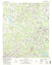 1992 Austell1992 Print · USGSThe western edges of the Atlanta metro area are captured here in the early nineties as Cobb and Douglas counties continued their suburban expansion. Genealogists and local historians can trace family roots through several rural burial sites like Coker-Elliott Cem and numerous local churches including Praise Tabernacle and County Line Ch.2 unique versions available
 - 1992 Map of Lost Mountain, 1993 Print
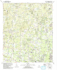 1992 Lost Mountain1993 Print · USGSCobb and Paulding counties appear here in the early nineties as suburban growth began to surround landmarks like Lost Mtn. Genealogists and historians can locate family-named landmarks and institutions such as Bullard Cem, McEachern Ch, and the Picketts Mill State Historical Site.
 - 1992 Map of Acworth, 1993 Print
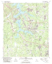 1992 Acworth1993 Print · USGSAcworth and the shores of Lake Allatoona are shown in the early nineties, a period of significant growth in Cobb County. Genealogists and local historians can locate established landmarks such as Liberty Hill Cem, Awtrey Middle Sch, and the CSX TRANSPORTATION line.2 unique versions available
 - 1999 Map of Austell, 2003 Print
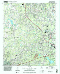 1999 Austell2003 Print · USGSThe growing suburban corridor west of Atlanta is captured here at the end of the millennium, showing a landscape defined by rail lines and winding creeks. You can trace family roots through numerous local landmarks like Rose Hill Cem, Souls Arbor Tabernacle, and Newman Bridge.
End of results
Showing maps 1-4 of 4
Top cities of Paulding County
Frequently asked questions
- What are the different types of historical maps available for Paulding County?
- What is the oldest map of Paulding County?
- Where can I purchase historical maps of Paulding County for my home or office?
- Where can I download high-res historical maps of Paulding County?
- Are there historical topographic maps available for Paulding County?
- Is there historical aerial imagery available for Paulding County?
- Where are historical maps of Paulding County sourced from?