1970s Maps of Pickens County, Georgia
Explore 9 historic maps of Pickens County from the 1970s. These maps offer a rare glimpse into what life looked like during the 1970s — showing old roads, neighborhoods, homes, and landmarks that have changed or disappeared over time.
Whether you're researching your family's past, planning a metal detecting trip, or studying how Pickens County's landscape evolved across the 1970s, these high-resolution maps are a powerful tool for exploring the history of this region.
- Focus on a specific era: All maps on this page are from the 1970s, giving you a focused view of this time period.
- See what’s changed: Compare century-old streets, trails, and buildings to today's modern landscape using overlays and satellite layers.
- Research with precision: Use these maps for genealogy, historical research, land use analysis, or educational projects.
- View, download, or print: Maps are fully viewable online in high resolution, and can be downloaded or printed for your own records.
Start exploring Pickens County's history through authentic maps from the 1970s. This is your window into the past.
Pickens County, GA maps
(9)- 1971 Map of Amicalola, 1973 Print
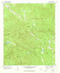 1971 Amicalola1973 Print · USGSNorth Georgia's high country is captured here in the early seventies as small mountain communities remained centered around local churches. Researchers can locate family sites near Little Ebenezer Cem, Antioch Ch, and the settlement of Amicalola.2 unique versions available
 - 1971 Map of Oakman, 1973 Print
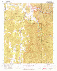 1971 Oakman1973 Print · USGSNorth Georgia’s mountain landscape is captured here during the 1970s as new reservoirs began to reshape the river valleys. Researchers can locate several rural churches and rail-side communities like Oakman, Hopewell Ch, and Sweden near the Louisville and Nashville line.2 unique versions available
 - 1971 Map of Dyke, 1973 Print
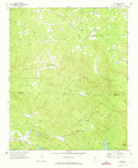 1971 Dyke1973 Print · USGSThe Gilmer and Pickens county line was a landscape of remote mountain valleys and dispersed homesteads in the early seventies. Researchers can trace family roots through sites like Clear Creek Ch, the Louisville and Nashville rail corridor, and Pleasant Valley.3 unique versions available
 - 1971 Map of Talking Rock, 1973 Print
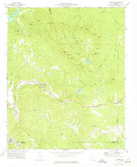
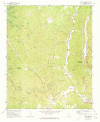 1971 Talking Rock1973 Print · USGSThe hill country of North Georgia is captured here just as Lake Carters began to fill in the early seventies. Genealogists and historians can trace family landmarks like Carns Mill, Southwestern Sch, and several rural churches including Town Creek Ch.3 unique versions available
 - 1972 Map of Fairmount, 1974 Print
 1972 Fairmount1974 Print · USGSFairmount and the Salacoa Valley are shown in the early seventies as the railroad and rural highway networks defined life in North Georgia. Researchers can trace family sites at Shiloh Cem, the remote community of Ryo, and the quarries near Funkhouser.2 unique versions available
 - 1972 Map of Ludville, 1974 Print
 1972 Ludville1974 Print · USGSIn the early 1970s, the rural landscapes of Pickens and Cherokee counties were dotted with small settlements and family churches. Trace the history of communities like Ludville, Hinton, and Jerusalem or find family landmarks like Friendship Ch and Pine Grove Ch.2 unique versions available
 - 1972 Map of Nelson, 1975 Print
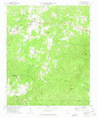
 1972 Nelson1975 Print · USGSNorth Georgia in the early seventies shows a landscape defined by marble extraction and mountain ridges at the meeting of three counties. Researchers can locate the Quarries of Marblehill, the Tate Lookout Tower, and rural landmarks like Long Swamp Ch.2 unique versions available
 - 1973 Map of Ball Ground West, 1975 Print
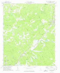 1973 Ball Ground West1975 Print · USGSCherokee County during the mid-seventies shows a landscape of river-valley towns and rural crossroads before the massive suburban expansion of later decades. Genealogists can trace family roots at Old Damascus Ch, Burris Crossroads, and along the Louisville and Nashville rail line.3 unique versions available
 - 1973 Map of Jasper, 1975 Print
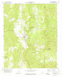
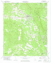 1973 Jasper1975 Print · USGSThe foothills of north Georgia are captured here in the 1970s, showcasing the industrial and spiritual hubs of Pickens County. Genealogists can trace family locations near Salem Ch, Philadelphia Ch, and the Louisville and Nashville rail line.2 unique versions available
End of results
Showing maps 1-9 of 9
Top cities of Pickens County
Frequently asked questions
- What are the different types of historical maps available for Pickens County?
- What is the oldest map of Pickens County?
- Where can I purchase historical maps of Pickens County for my home or office?
- Where can I download high-res historical maps of Pickens County?
- Are there historical topographic maps available for Pickens County?
- Is there historical aerial imagery available for Pickens County?
- Where are historical maps of Pickens County sourced from?