1970s Maps of Blackshear, Georgia
Explore 3 historic maps of Blackshear from the 1970s. These maps offer a rare glimpse into what life looked like during the 1970s — showing old roads, neighborhoods, homes, and landmarks that have changed or disappeared over time.
Whether you're researching your family's past, planning a metal detecting trip, or studying how Blackshear's landscape evolved across the 1970s, these high-resolution maps are a powerful tool for exploring the history of this region.
- Focus on a specific era: All maps on this page are from the 1970s, giving you a focused view of this time period.
- See what’s changed: Compare century-old streets, trails, and buildings to today's modern landscape using overlays and satellite layers.
- Research with precision: Use these maps for genealogy, historical research, land use analysis, or educational projects.
- View, download, or print: Maps are fully viewable online in high resolution, and can be downloaded or printed for your own records.
Start exploring Blackshear's history through authentic maps from the 1970s. This is your window into the past.
Blackshear, GA maps
(3)- 1971 Map of Blackshear East, 1974 Print
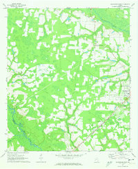 1971 Blackshear East1974 Print · USGSPierce County in the early seventies remains a landscape of rural family settlements and small country churches. Genealogists can trace local roots at the Jot 'Em Down Store, Homestead Ch, and the Seaboard Coast Line rail corridor.2 unique versions available
 - 1971 Map of Blackshear West, 1974 Print
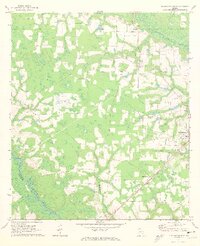 1971 Blackshear West1974 Print · USGSPierce County in the early seventies reveals a landscape of river-bottom lowlands and rural community hubs. Researchers can locate family landmarks like Sweat Cem and Nunn Cem or trace the Seaboard Coast Line through Homestead.2 unique versions available
 - 1978 Map of Waycross, 1982 Print
 1978 Waycross1982 Print · USGSSoutheast Georgia in the late seventies is a landscape of vast wetlands and busy rail junctions. Genealogists and local historians can trace the Seaboard Coast Line through rural stops like Millwood and Pearson or locate family sites near the Okefenokee Swamp.
End of results
Showing maps 1-3 of 3
Top cities near Blackshear
- Waycross historical maps
- Alma historical maps
- Patterson historical maps
- Hoboken historical maps
- Offerman historical maps
Frequently asked questions
- What are the different types of historical maps available for Blackshear?
- What is the oldest map of Blackshear?
- Where can I purchase historical maps of Blackshear for my home or office?
- Where can I download high-res historical maps of Blackshear?
- Are there historical topographic maps available for Blackshear?
- Is there historical aerial imagery available for Blackshear?
- Where are historical maps of Blackshear sourced from?