1970s Maps of Polk County, Georgia
Explore 5 historic maps of Polk County from the 1970s. These maps offer a rare glimpse into what life looked like during the 1970s — showing old roads, neighborhoods, homes, and landmarks that have changed or disappeared over time.
Whether you're researching your family's past, planning a metal detecting trip, or studying how Polk County's landscape evolved across the 1970s, these high-resolution maps are a powerful tool for exploring the history of this region.
- Focus on a specific era: All maps on this page are from the 1970s, giving you a focused view of this time period.
- See what’s changed: Compare century-old streets, trails, and buildings to today's modern landscape using overlays and satellite layers.
- Research with precision: Use these maps for genealogy, historical research, land use analysis, or educational projects.
- View, download, or print: Maps are fully viewable online in high resolution, and can be downloaded or printed for your own records.
Start exploring Polk County's history through authentic maps from the 1970s. This is your window into the past.
Polk County, GA maps
(5)- 1972 Map of Taylorsville, 1974 Print
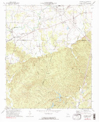 1972 Taylorsville1974 Print · USGSThe rural borderlands of Bartow and Polk counties are captured here in the early 1970s, showing a landscape defined by valley farming and rail junctions. You can trace local genealogy and land use through landmarks like Taylorsville Sch, Euharlee Ch, and the Claypit near the Seaboard tracks.2 unique versions available
 - 1973 Map of Felton, 1975 Print
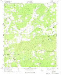 1973 Felton1975 Print · USGSThe rural border of Polk and Haralson Counties is documented here in the early 1970s, showing a landscape of ridgelines and mountain valleys. Researchers can trace families and communities through landmarks like Felton, Hightower Falls, and old country churches such as Bethlehem Ch and Youngs Grove Ch.2 unique versions available
 - 1973 Map of Yorkville, 1975 Print
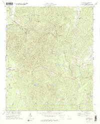 1973 Yorkville1975 Print · USGSThe Paulding County highlands come into focus in the early 1970s as a landscape of rural communities and railroad junctions. Researchers can trace family sites at Yorkville or New Liberty Ch and locate historic industrial markers like the Ship Mine.2 unique versions available
 - 1973 Map of Rockmart South, 1975 Print
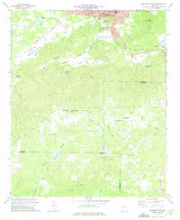 1973 Rockmart South1975 Print · USGSThe industrial and rural landscape of Polk County comes into focus in the early 1970s, from the rail yards of Rockmart to the banks of the TALLAPOOSA RIVER. Researchers can trace old family settlements and local landmarks like Van Wert, Noah Chapel, and the County Line Cem.2 unique versions available
 - 1975 Map of Borden Springs, 1977 Print
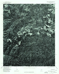 1975 Borden Springs1977 Print · USGSThe Alabama and Georgia borderlands are captured in clear aerial detail during the mid-1970s. Local history enthusiasts can trace the exact buildings and road networks surrounding Borden Springs and the border settlement of Esom Hill.
End of results
Showing maps 1-5 of 5
Top cities of Polk County
Frequently asked questions
- What are the different types of historical maps available for Polk County?
- What is the oldest map of Polk County?
- Where can I purchase historical maps of Polk County for my home or office?
- Where can I download high-res historical maps of Polk County?
- Are there historical topographic maps available for Polk County?
- Is there historical aerial imagery available for Polk County?
- Where are historical maps of Polk County sourced from?