1900s (20th Century) Maps of Mountain City, Georgia
Explore 11 historic maps of Mountain City from the 1900s (20th Century). These maps offer a rare glimpse into what life looked like during the 1900s — showing old roads, neighborhoods, homes, and landmarks that have changed or disappeared over time.
Whether you're researching your family's past, planning a metal detecting trip, or studying how Mountain City's landscape evolved across the 1900s, these high-resolution maps are a powerful tool for exploring the history of this region.
- Focus on a specific era: All maps on this page are from the 1900s, giving you a focused view of this time period.
- See what’s changed: Compare century-old streets, trails, and buildings to today's modern landscape using overlays and satellite layers.
- Research with precision: Use these maps for genealogy, historical research, land use analysis, or educational projects.
- View, download, or print: Maps are fully viewable online in high resolution, and can be downloaded or printed for your own records.
Start exploring Mountain City's history through authentic maps from the 1900s. This is your window into the past.
Mountain City, GA maps
(11)- 1935 Map of Dillard
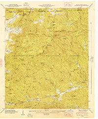
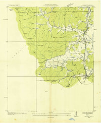 1935 Dillard1935 Print · USGSThe Georgia and North Carolina borderlands are captured here in the mid-1930s as the rail and highway networks expanded through the mountains. Researchers can locate the Rabun Gap Nacoochee Sch, trace the Tallulah Falls RR, and find local landmarks like Wolf Fork Ch.
 - 1935 Map of Rabun Bald
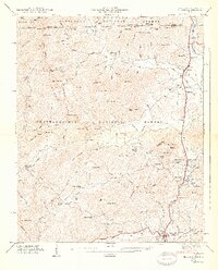
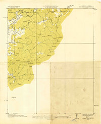 1935 Rabun Bald1935 Print · USGSThe Georgia and North Carolina high country is captured here during the mid-thirties, dominated by the ridge lines of the Blue Ridge. Researchers can trace old mountain trails to landmarks like the Fire Tower at Rabun Bald or locate family sites near Dillard and Stillhouse Creek.
 - 1946 Map of Dillard, 1956 Print
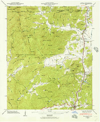 1946 Dillard1956 Print · USGSRabun County mountain life is captured here in the years following the war, centered on the vital passage through Rabun Gap. Local historians can trace the Tallulah Falls RR and locate the Queen Mine, Kilby Mill, and the Rabun Gap Nacoochee Sch.4 unique versions available
 - 1946 Map of Rabun Bald, 1956 Print
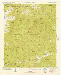 1946 Rabun Bald1956 Print · USGSThe Blue Ridge high country of Georgia and North Carolina is surveyed here just after the war. Local researchers can find family landmarks like Locust School, Hale Church Cem, and the high-elevation flats near Rabun Bald.4 unique versions available
 - 1947 Map of Rabun Bald
 1947 Rabun Bald1947 Print · USGSThe Georgia-North Carolina borderlands appear in the late 1940s as a landscape of isolated mountain communities and forest preserves. Genealogists can locate family landmarks such as Locust School, Hale Church Cem, and the high summit of Rabun Bald.2 unique versions available
 - 1947 Map of Dillard
 1947 Dillard1947 Print · USGSNorth Georgia and the Carolina border are mapped here just after the war, showing the mountain communities at the headwaters of the Little Tennessee River. Genealogists and historians can locate family landmarks like Wesley Chapel Cem, Dickerson Mill, and the Rabun Gap Nacoochee Sch.2 unique versions available
 - 1954 Map of Greenville, 1965 Print
 1954 Greenville1965 Print · USGSThe Upstate and Northeast Georgia are captured here during a decade of massive transformation as new reservoirs reshaped the Piedmont. Genealogists and hikers can trace the Appalachian Trail over Brasstown Bald or locate old community centers like Demorest, Westminster, and Royston.3 unique versions available
 - 1958 Map of Greenville
 1958 Greenville1958 Print · USGSThe Piedmont and Blue Ridge foothills come alive in this mid-century survey of the Upstate and Northeast Georgia. Trace the regional rail-and-river economy through the Southern Railway corridors and early reservoir developments like Lake Sidney Lanier.
 - 1981 Map of Toccoa, 1982 Print
 1981 Toccoa1982 Print · USGSThe tri-state mountain region where Georgia meets the Carolinas is shown here in the early eighties. Genealogists and historians can trace family-named locations and settlements from Dahlonega to Tallulah Falls, along with the Southern rail corridor.2 unique versions available
 - 1988 Map of Dillard
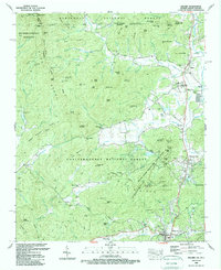 1988 Dillard1988 Print · USGSThe high divide of the Blue Ridge Mountains comes alive in the late eighties as Georgia and North Carolina meet. Genealogists and hikers can trace family sites like Germany Cem, schools such as Rabun Gap Nacoochee Sch, and the winding Appalachian National Scenic Trail.2 unique versions available
 - 1988 Map of Rabun Bald
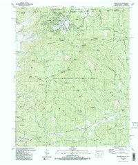 1988 Rabun Bald1988 Print · USGSThe Blue Ridge high country along the Georgia and North Carolina border is captured here in the late eighties. Researchers can trace family history through sites like Kelly Cem, Hale Church, and the high-elevation Locust School Gap.2 unique versions available
End of results
Showing maps 1-11 of 11
Top cities near Mountain City
- Franklin historical maps
- Clayton historical maps
- Tiger historical maps
- Dillard historical maps
- Sky Valley historical maps
Frequently asked questions
- What are the different types of historical maps available for Mountain City?
- What is the oldest map of Mountain City?
- Where can I purchase historical maps of Mountain City for my home or office?
- Where can I download high-res historical maps of Mountain City?
- Are there historical topographic maps available for Mountain City?
- Is there historical aerial imagery available for Mountain City?
- Where are historical maps of Mountain City sourced from?