1960s Maps of Rockdale County, Georgia
Explore 6 historic maps of Rockdale County from the 1960s. These maps offer a rare glimpse into what life looked like during the 1960s — showing old roads, neighborhoods, homes, and landmarks that have changed or disappeared over time.
Whether you're researching your family's past, planning a metal detecting trip, or studying how Rockdale County's landscape evolved across the 1960s, these high-resolution maps are a powerful tool for exploring the history of this region.
- Focus on a specific era: All maps on this page are from the 1960s, giving you a focused view of this time period.
- See what’s changed: Compare century-old streets, trails, and buildings to today's modern landscape using overlays and satellite layers.
- Research with precision: Use these maps for genealogy, historical research, land use analysis, or educational projects.
- View, download, or print: Maps are fully viewable online in high resolution, and can be downloaded or printed for your own records.
Start exploring Rockdale County's history through authentic maps from the 1960s. This is your window into the past.
Rockdale County, GA maps
(6)- 1963 Map of Athens
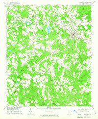
 1963 Athens1963 Print · USGSGeorgia's Piedmont and the Savannah River valley are captured in the early sixties as major reservoirs and military installations reshaped the landscape. Researchers can trace the development of Clark Hill Reservoir, locate the Fort Gordon Military Reservation, and find historic towns like Social Circle and Eatonton.
 - 1964 Map of Loganville, 1965 Print
 1964 Loganville1965 Print · USGSLoganville and its rural surroundings appear here in the mid-sixties, where the corners of Walton, Gwinnett, and Rockdale counties converge. Researchers can trace family roots at Old Zion Cem or locate the site of McElroys Mill on the banks of Haynes Creek.2 unique versions available
 - 1964 Map of Porterdale, 1966 Print
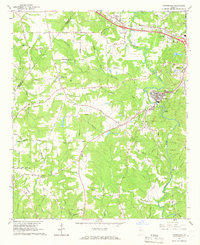 1964 Porterdale1966 Print · USGSNewton County's river-driven industry and rural crossroads are captured here in the mid-1960s as the suburbs of Atlanta began to reach eastward. Researchers can trace family roots at Salem Campground, Richards Chapel, and the now-familiar streets of Porterdale.4 unique versions available
 - 1964 Map of Kelleytown, 1966 Print
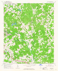
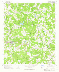
 1964 Kelleytown1966 Print · USGSRockdale and Henry counties appear in the mid-1960s as a landscape of rural family farms and quiet crossroads. Researchers can locate legacy family sites and landmarks including Kelleytown, the Monastery of the Holy Ghost, and the Whitaker Cem.3 unique versions available
 - 1964 Map of Milstead, 1966 Print
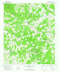
 1964 Milstead1966 Print · USGSThe Yellow River valley of northern Georgia is shown in the mid-1960s, a period when rural church communities and historic mill sites still defined the landscape. Genealogists and historians can trace family locations near Milstead, Philadelphia Ch, and Costley Millpond.4 unique versions available
 - 1964 Map of Stockbridge, 1966 Print
 1964 Stockbridge1966 Print · USGSStockbridge and its rural Henry County surroundings are captured in the mid-1960s as the area transitions from a mill-and-rail economy to modern settlement. Genealogists and historians can trace family-named sites like Millers Mill, Hannahs Millpond, and Price Quarters along the creek valleys.3 unique versions available
End of results
Showing maps 1-6 of 6
Top cities of Rockdale County
Frequently asked questions
- What are the different types of historical maps available for Rockdale County?
- What is the oldest map of Rockdale County?
- Where can I purchase historical maps of Rockdale County for my home or office?
- Where can I download high-res historical maps of Rockdale County?
- Are there historical topographic maps available for Rockdale County?
- Is there historical aerial imagery available for Rockdale County?
- Where are historical maps of Rockdale County sourced from?