1930s Maps of Hiawassee, Georgia
Explore 2 historic maps of Hiawassee from the 1930s. These maps offer a rare glimpse into what life looked like during the 1930s — showing old roads, neighborhoods, homes, and landmarks that have changed or disappeared over time.
Whether you're researching your family's past, planning a metal detecting trip, or studying how Hiawassee's landscape evolved across the 1930s, these high-resolution maps are a powerful tool for exploring the history of this region.
- Focus on a specific era: All maps on this page are from the 1930s, giving you a focused view of this time period.
- See what’s changed: Compare century-old streets, trails, and buildings to today's modern landscape using overlays and satellite layers.
- Research with precision: Use these maps for genealogy, historical research, land use analysis, or educational projects.
- View, download, or print: Maps are fully viewable online in high resolution, and can be downloaded or printed for your own records.
Start exploring Hiawassee's history through authentic maps from the 1930s. This is your window into the past.
Hiawassee, GA maps
(2)- 1935 Map of Osborn
 1935 Osborn1935 Print · USGSTowns County, Georgia, is documented here in the mid-1930s before the full expansion of the Tennessee Valley Authority’s projects. Local historians can trace family locations and rural community hubs like Osborn, Macedonia Ch, and Upper Bell Sch.
 - 1935 Map of Hiawassee
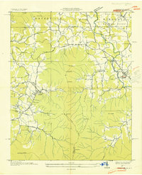 1935 Hiawassee1935 Print · USGSThe Georgia-North Carolina border country comes alive in the mid-1930s, showing the early infrastructure of the Appalachian highlands. You can trace family history through sites like Young Harris, Townsend Mill, and the Lower Bell Creek School.
End of results
Showing maps 1-2 of 2
Top cities near Hiawassee
Frequently asked questions
- What are the different types of historical maps available for Hiawassee?
- What is the oldest map of Hiawassee?
- Where can I purchase historical maps of Hiawassee for my home or office?
- Where can I download high-res historical maps of Hiawassee?
- Are there historical topographic maps available for Hiawassee?
- Is there historical aerial imagery available for Hiawassee?
- Where are historical maps of Hiawassee sourced from?