1970s Maps of Treutlen County, Georgia
Explore 9 historic maps of Treutlen County from the 1970s. These maps offer a rare glimpse into what life looked like during the 1970s — showing old roads, neighborhoods, homes, and landmarks that have changed or disappeared over time.
Whether you're researching your family's past, planning a metal detecting trip, or studying how Treutlen County's landscape evolved across the 1970s, these high-resolution maps are a powerful tool for exploring the history of this region.
- Focus on a specific era: All maps on this page are from the 1970s, giving you a focused view of this time period.
- See what’s changed: Compare century-old streets, trails, and buildings to today's modern landscape using overlays and satellite layers.
- Research with precision: Use these maps for genealogy, historical research, land use analysis, or educational projects.
- View, download, or print: Maps are fully viewable online in high resolution, and can be downloaded or printed for your own records.
Start exploring Treutlen County's history through authentic maps from the 1970s. This is your window into the past.
Treutlen County, GA maps
(9)- 1970 Map of Oak Park SW, 1973 Print
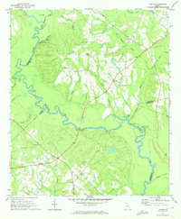
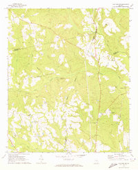 1970 Oak Park SW1973 Print · USGSSoutheast Georgia in the early 1970s reveals a patchwork of rural cemeteries and cross-county rail lines at the intersection of Montgomery and Toombs counties. Researchers can trace family history through sites like Mosleytown, Mc Leod Grave, and Blockers Chapel.
 - 1970 Map of Covena, 1973 Print
 1970 Covena1973 Print · USGSCoastal plain settlements and timberlands along the Ohoopee River define this Georgia landscape in the early seventies. Genealogists can trace family landmarks and rural communities through sites like Thigpen Chapel, Wilkes Cem, and the Old Railroad Grade.2 unique versions available
 - 1971 Map of Soperton South, 1973 Print
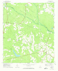
 1971 Soperton South1973 Print · USGSSoutheast Georgia in the early seventies is revealed here through its transition from Treutlen to Montgomery County. Genealogists and historians can trace family locations near Tarrytown, Kibbee, and Hamilton Hill Cem along the Seaboard Coast Line.
 - 1971 Map of Soperton North, 1973 Print
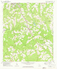
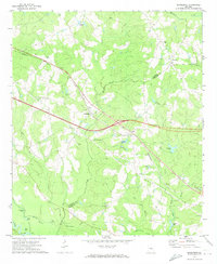
 1971 Soperton North1973 Print · USGSTreutlen and Emanuel Counties are shown in the early seventies as a new highway was cutting across the landscape. Genealogists can trace family roots at Johnson Chapel Cem, Ricks Cem, or the Lookout Tower Harmony Ch.2 unique versions available
 - 1971 Map of Lothair, 1973 Print
 1971 Lothair1973 Print · USGSThe Oconee River bottomlands at the start of the 1970s reveal a quiet corner of Georgia where four counties meet. Genealogists and local historians can locate the Gov Troup Grave and trace rural life through landmarks like Lothair, Beulah Ch, and Clabber Landing.
 - 1971 Map of Rockledge, 1974 Print
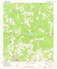
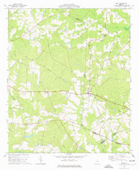
 1971 Rockledge1974 Print · USGSLaurens and Treutlen counties in the early 1970s show a landscape of traditional river landings and rail-side settlements being transformed by new highway projects. Researchers can trace family history at Norris Chapel, visit the river at Stave Landing, or follow the Seaboard Coast Line through Rockledge.2 unique versions available
 - 1974 Map of Scott, 1976 Print
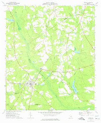
 1974 Scott1976 Print · USGSLife in mid-1970s Laurens and Johnson Counties centered on the town of Scott and its network of rural congregations. Researchers can trace family history through numerous landmarks including Beasley Cem, St Pauls Ch, and the Old Railroad Grade.
 - 1974 Map of Adrian, 1976 Print
 1974 Adrian1976 Print · USGSAdrian and the surrounding pine-country creek bottoms are documented here in the mid-seventies, spanning three Georgia counties. Researchers can trace the legacy of local transport along the Old Railroad Grade and find family sites at Bethsaida Ch or Braswell Cem.
 - 1979 Map of Vidalia, 1980 Print
 1979 Vidalia1980 Print · USGSSoutheast Georgia in the late 1970s is a landscape of river-bend settlements and crossing rail lines. Researchers can trace family roots and land patterns through several towns like Vidalia, Soperton, and Mount Vernon, or locate regional landmarks like the State Prison.2 unique versions available
End of results
Showing maps 1-9 of 9
Top cities of Treutlen County
Frequently asked questions
- What are the different types of historical maps available for Treutlen County?
- What is the oldest map of Treutlen County?
- Where can I purchase historical maps of Treutlen County for my home or office?
- Where can I download high-res historical maps of Treutlen County?
- Are there historical topographic maps available for Treutlen County?
- Is there historical aerial imagery available for Treutlen County?
- Where are historical maps of Treutlen County sourced from?