1960s Maps of View Pointe, Georgia
Explore 1 historic maps of View Pointe from the 1960s. These maps offer a rare glimpse into what life looked like during the 1960s — showing old roads, neighborhoods, homes, and landmarks that have changed or disappeared over time.
Whether you're researching your family's past, planning a metal detecting trip, or studying how View Pointe's landscape evolved across the 1960s, these high-resolution maps are a powerful tool for exploring the history of this region.
- Focus on a specific era: All maps on this page are from the 1960s, giving you a focused view of this time period.
- See what’s changed: Compare century-old streets, trails, and buildings to today's modern landscape using overlays and satellite layers.
- Research with precision: Use these maps for genealogy, historical research, land use analysis, or educational projects.
- View, download, or print: Maps are fully viewable online in high resolution, and can be downloaded or printed for your own records.
Start exploring View Pointe's history through authentic maps from the 1960s. This is your window into the past.
View Pointe, GA maps
(1)- 1964 Map of La Grange, 1966 Print
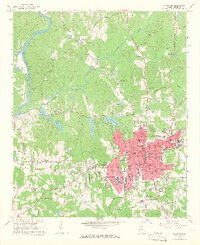 1964 La Grange1966 Print · USGSLa Grange and Troup County appear in the mid-sixties as a thriving textile and education center just east of the Chattahoochee. Researchers can trace the town's expansion through sites like La Grange College, Stonewall Cem, and the Dunson Mills Sch.3 unique versions available
End of results
Showing maps 1-1 of 1
Top cities near View Pointe
- LaGrange historical maps
- Lanett historical maps
- West Point historical maps
- Grantville historical maps
- Hogansville historical maps
- Pine Mountain historical maps
See more
Frequently asked questions
- What are the different types of historical maps available for View Pointe?
- What is the oldest map of View Pointe?
- Where can I purchase historical maps of View Pointe for my home or office?
- Where can I download high-res historical maps of View Pointe?
- Are there historical topographic maps available for View Pointe?
- Is there historical aerial imagery available for View Pointe?
- Where are historical maps of View Pointe sourced from?