1940s Maps of Reo, Georgia
Explore 2 historic maps of Reo from the 1940s. These maps offer a rare glimpse into what life looked like during the 1940s — showing old roads, neighborhoods, homes, and landmarks that have changed or disappeared over time.
Whether you're researching your family's past, planning a metal detecting trip, or studying how Reo's landscape evolved across the 1940s, these high-resolution maps are a powerful tool for exploring the history of this region.
- Focus on a specific era: All maps on this page are from the 1940s, giving you a focused view of this time period.
- See what’s changed: Compare century-old streets, trails, and buildings to today's modern landscape using overlays and satellite layers.
- Research with precision: Use these maps for genealogy, historical research, land use analysis, or educational projects.
- View, download, or print: Maps are fully viewable online in high resolution, and can be downloaded or printed for your own records.
Start exploring Reo's history through authentic maps from the 1940s. This is your window into the past.
Reo, GA maps
(2)- 1946 Map of Villanow, 1964 Print
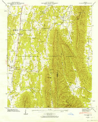 1946 Villanow1964 Print · USGSNorthwestern Georgia’s ridges and hollows appear in detail just after the war, showing the rural communities along the Whitfield and Walker County line. Genealogists and hikers can trace old cemeteries and mountain passes, from Villanow and Snake Creek Gap to Redwine Cove Cem.3 unique versions available
 - 1947 Map of Villanow
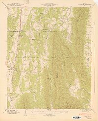 1947 Villanow1947 Print · USGSThe Whitfield and Walker County line comes alive in this late 1940s survey of the Georgia uplands. Genealogists can locate family landmarks like Phillips Cem, Redwine Cove Cem, and the historic settlement at Villanow.2 unique versions available
End of results
Showing maps 1-2 of 2
Top cities near Reo
- Dalton historical maps
- Calhoun historical maps
- Fort Oglethorpe historical maps
- LaFayette historical maps
- Summerville historical maps
- Ringgold historical maps
See more
Frequently asked questions
- What are the different types of historical maps available for Reo?
- What is the oldest map of Reo?
- Where can I purchase historical maps of Reo for my home or office?
- Where can I download high-res historical maps of Reo?
- Are there historical topographic maps available for Reo?
- Is there historical aerial imagery available for Reo?
- Where are historical maps of Reo sourced from?