1970s Maps of Davisboro, Georgia
Explore 2 historic maps of Davisboro from the 1970s. These maps offer a rare glimpse into what life looked like during the 1970s — showing old roads, neighborhoods, homes, and landmarks that have changed or disappeared over time.
Whether you're researching your family's past, planning a metal detecting trip, or studying how Davisboro's landscape evolved across the 1970s, these high-resolution maps are a powerful tool for exploring the history of this region.
- Focus on a specific era: All maps on this page are from the 1970s, giving you a focused view of this time period.
- See what’s changed: Compare century-old streets, trails, and buildings to today's modern landscape using overlays and satellite layers.
- Research with precision: Use these maps for genealogy, historical research, land use analysis, or educational projects.
- View, download, or print: Maps are fully viewable online in high resolution, and can be downloaded or printed for your own records.
Start exploring Davisboro's history through authentic maps from the 1970s. This is your window into the past.
Davisboro, GA maps
(2)- 1972 Map of Grange, 1974 Print
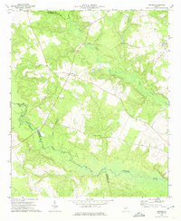 1972 Grange1974 Print · USGSJefferson County was defined by its winding waterways and rural church communities in the early 1970s. Genealogists can locate family landmarks like Stapletons Crossroads, Hardman-Springfield Ch, and the banks of the Ogeechee River.2 unique versions available
 - 1974 Map of Davisboro, 1976 Print
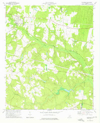 1974 Davisboro1976 Print · USGSMid-seventies Washington County comes alive in this survey of the rail-and-creek landscape near Davisboro. Researchers can locate several rural landmarks including Mt Zion Ch, Almira, and the marshy reaches of Williamson Swamp Creek.
End of results
Showing maps 1-2 of 2
Top cities near Davisboro
- Sandersville historical maps
- Louisville historical maps
- Wadley historical maps
- Wrens historical maps
- Tennille historical maps
- Harrison historical maps
See more
Frequently asked questions
- What are the different types of historical maps available for Davisboro?
- What is the oldest map of Davisboro?
- Where can I purchase historical maps of Davisboro for my home or office?
- Where can I download high-res historical maps of Davisboro?
- Are there historical topographic maps available for Davisboro?
- Is there historical aerial imagery available for Davisboro?
- Where are historical maps of Davisboro sourced from?