1940s Maps of O Neal, Georgia
Explore 3 historic maps of O Neal from the 1940s. These maps offer a rare glimpse into what life looked like during the 1940s — showing old roads, neighborhoods, homes, and landmarks that have changed or disappeared over time.
Whether you're researching your family's past, planning a metal detecting trip, or studying how O Neal's landscape evolved across the 1940s, these high-resolution maps are a powerful tool for exploring the history of this region.
- Focus on a specific era: All maps on this page are from the 1940s, giving you a focused view of this time period.
- See what’s changed: Compare century-old streets, trails, and buildings to today's modern landscape using overlays and satellite layers.
- Research with precision: Use these maps for genealogy, historical research, land use analysis, or educational projects.
- View, download, or print: Maps are fully viewable online in high resolution, and can be downloaded or printed for your own records.
Start exploring O Neal's history through authentic maps from the 1940s. This is your window into the past.
O Neal, GA maps
(3)- 1944 Map of Hortense
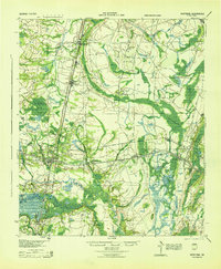 1944 Hortense1944 Print · USGSCoastal Georgia during the mid-forties reveals a landscape defined by the Satilla River and a strategic intersection of two major railroads. Genealogists can trace family roots through rural landmarks like Manningtown, Oak Grove Ch, and Menor Sch.
 - 1946 Map of Brunswick, 1948 Print
 1946 Brunswick1948 Print · USGSCoastal Georgia in the mid-forties reveals a landscape defined by the Camp Stewart Military Reservation and the sprawling barrier islands. Genealogists and historians can trace the rail-and-river network through inland towns like Ludowici and Jesup, or locate coastal landmarks like the St Simon Light.
 - 1948 Map of Brunswick
 1948 Brunswick1948 Print · USGSCoastal Georgia in the late 1940s is defined here by its labyrinthine barrier islands and the massive footprint of Camp Stewart. Genealogists and historians can trace the rail-tied growth of Jesup and Hinesville or locate coastal landmarks like St Simon Light.
End of results
Showing maps 1-3 of 3
Top cities near O Neal
- Jesup historical maps
- Nahunta historical maps
- Screven historical maps
- Patterson historical maps
- Hoboken historical maps
- Offerman historical maps
See more
Frequently asked questions
- What are the different types of historical maps available for O Neal?
- What is the oldest map of O Neal?
- Where can I purchase historical maps of O Neal for my home or office?
- Where can I download high-res historical maps of O Neal?
- Are there historical topographic maps available for O Neal?
- Is there historical aerial imagery available for O Neal?
- Where are historical maps of O Neal sourced from?