1940s Maps of Rocky Face, Georgia
Explore 1 historic maps of Rocky Face from the 1940s. These maps offer a rare glimpse into what life looked like during the 1940s — showing old roads, neighborhoods, homes, and landmarks that have changed or disappeared over time.
Whether you're researching your family's past, planning a metal detecting trip, or studying how Rocky Face's landscape evolved across the 1940s, these high-resolution maps are a powerful tool for exploring the history of this region.
- Focus on a specific era: All maps on this page are from the 1940s, giving you a focused view of this time period.
- See what’s changed: Compare century-old streets, trails, and buildings to today's modern landscape using overlays and satellite layers.
- Research with precision: Use these maps for genealogy, historical research, land use analysis, or educational projects.
- View, download, or print: Maps are fully viewable online in high resolution, and can be downloaded or printed for your own records.
Start exploring Rocky Face's history through authentic maps from the 1940s. This is your window into the past.
Rocky Face, GA maps
(1)- 1943 Map of Tunnel Hill, 1946 Print
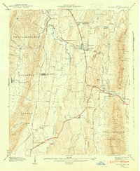 1943 Tunnel Hill1946 Print · USGSWhitfield and Catoosa Counties are shown here during the mid-1940s, a period when mountain ridges still dictated the flow of commerce and travel. Genealogists and historians can locate numerous small churches and family landmarks like New Hope Ch, Callaway Mill, and the Chattanooga and Nashville Railroad tunnel.5 unique versions available
End of results
Showing maps 1-1 of 1
Top cities near Rocky Face
- Chattanooga historical maps
- Dalton historical maps
- East Ridge historical maps
- East Ridge historical maps
- Fort Oglethorpe historical maps
- Collegedale historical maps
See more
Frequently asked questions
- What are the different types of historical maps available for Rocky Face?
- What is the oldest map of Rocky Face?
- Where can I purchase historical maps of Rocky Face for my home or office?
- Where can I download high-res historical maps of Rocky Face?
- Are there historical topographic maps available for Rocky Face?
- Is there historical aerial imagery available for Rocky Face?
- Where are historical maps of Rocky Face sourced from?