1970s Maps of Gordon, Georgia
Explore 3 historic maps of Gordon from the 1970s. These maps offer a rare glimpse into what life looked like during the 1970s — showing old roads, neighborhoods, homes, and landmarks that have changed or disappeared over time.
Whether you're researching your family's past, planning a metal detecting trip, or studying how Gordon's landscape evolved across the 1970s, these high-resolution maps are a powerful tool for exploring the history of this region.
- Focus on a specific era: All maps on this page are from the 1970s, giving you a focused view of this time period.
- See what’s changed: Compare century-old streets, trails, and buildings to today's modern landscape using overlays and satellite layers.
- Research with precision: Use these maps for genealogy, historical research, land use analysis, or educational projects.
- View, download, or print: Maps are fully viewable online in high resolution, and can be downloaded or printed for your own records.
Start exploring Gordon's history through authentic maps from the 1970s. This is your window into the past.
Gordon, GA maps
(3)- 1973 Map of Gordon, 1977 Print
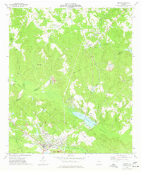 1973 Gordon1977 Print · USGSWilkinson County industries and rural rail stops are in focus during the early seventies. Genealogists and historians can trace family locations near Stevens Pottery, Lake Tchutolako, and several country churches like Emmanuel Ch or Smith Chapel.2 unique versions available
 - 1973 Map of Massey Hill, 1977 Print
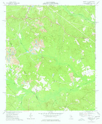 1973 Massey Hill1977 Print · USGSWilkinson and Twiggs counties appear here in the early 1970s, showcasing a landscape shaped by the kaolin industry and rural community life. Genealogists and historians can locate numerous landmarks like Spring Hill Ch Cem, Asbury Ch, and the Old Grade Railroad.
 - 1978 Map of Macon, 1980 Print
 1978 Macon1980 Print · USGSCentral Georgia during the late seventies reveals a landscape shaped by military expansion and clay mining. Genealogists and local historians can trace the development of Warner Robins, the grounds of Wesleyan College, and the rural surroundings of Griswoldville.2 unique versions available
End of results
Showing maps 1-3 of 3
Top cities near Gordon
- Macon historical maps
- Milledgeville historical maps
- Hardwick historical maps
- Gray historical maps
- Jeffersonville historical maps
- Ivey historical maps
See more
Frequently asked questions
- What are the different types of historical maps available for Gordon?
- What is the oldest map of Gordon?
- Where can I purchase historical maps of Gordon for my home or office?
- Where can I download high-res historical maps of Gordon?
- Are there historical topographic maps available for Gordon?
- Is there historical aerial imagery available for Gordon?
- Where are historical maps of Gordon sourced from?