1960s Maps of Ainaloa, Hawaii
Explore 3 historic maps of Ainaloa from the 1960s. These maps offer a rare glimpse into what life looked like during the 1960s — showing old roads, neighborhoods, homes, and landmarks that have changed or disappeared over time.
Whether you're researching your family's past, planning a metal detecting trip, or studying how Ainaloa's landscape evolved across the 1960s, these high-resolution maps are a powerful tool for exploring the history of this region.
- Focus on a specific era: All maps on this page are from the 1960s, giving you a focused view of this time period.
- See what’s changed: Compare century-old streets, trails, and buildings to today's modern landscape using overlays and satellite layers.
- Research with precision: Use these maps for genealogy, historical research, land use analysis, or educational projects.
- View, download, or print: Maps are fully viewable online in high resolution, and can be downloaded or printed for your own records.
Start exploring Ainaloa's history through authentic maps from the 1960s. This is your window into the past.
Ainaloa, HI maps
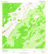
(3)- 1961 Map of Hawaii North
 1961 Hawaii North1961 Print · USGSThe Big Island's northern reaches are shown here in the early sixties, during the peak of the sugar era and before modern resort development. Researchers can trace the Hawaii Consolidated railroad, locate the Ahu a Umi Heiau Ruins, and explore sugar industry landmarks like the Pacific Sugar Mill.2 unique versions available
 - 1963 Map of Mountain View, 1964 Print
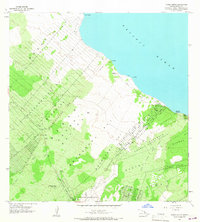
 1963 Mountain View1964 Print · USGSThe Puna District comes to life in the early sixties, showing the agricultural settlements and numbered camps that defined local life. Trace family land in Olaa Reservation Homesteads and locate historic sites like Kurtistown Sch or Olaa Dispensary.2 unique versions available
 - 1965 Map of Pahoa North, 1967 Print
 1965 Pahoa North1967 Print · USGSThe Puna coast in the mid-1960s reveals a unique landscape shaped by volcanic history and early homesteading. Researchers can trace the massive Lava Flow 1840, explore the remote Honolulu Landing, and locate the Makuu (Site) along the shore.2 unique versions available
End of results
Showing maps 1-3 of 3
Top cities near Ainaloa
Top neighborhoods of Ainaloa
Frequently asked questions
- What are the different types of historical maps available for Ainaloa?
- What is the oldest map of Ainaloa?
- Where can I purchase historical maps of Ainaloa for my home or office?
- Where can I download high-res historical maps of Ainaloa?
- Are there historical topographic maps available for Ainaloa?
- Is there historical aerial imagery available for Ainaloa?
- Where are historical maps of Ainaloa sourced from?