1990s Maps of Ainaloa, Hawaii
Explore 2 historic maps of Ainaloa from the 1990s. These maps offer a rare glimpse into what life looked like during the 1990s — showing old roads, neighborhoods, homes, and landmarks that have changed or disappeared over time.
Whether you're researching your family's past, planning a metal detecting trip, or studying how Ainaloa's landscape evolved across the 1990s, these high-resolution maps are a powerful tool for exploring the history of this region.
- Focus on a specific era: All maps on this page are from the 1990s, giving you a focused view of this time period.
- See what’s changed: Compare century-old streets, trails, and buildings to today's modern landscape using overlays and satellite layers.
- Research with precision: Use these maps for genealogy, historical research, land use analysis, or educational projects.
- View, download, or print: Maps are fully viewable online in high resolution, and can be downloaded or printed for your own records.
Start exploring Ainaloa's history through authentic maps from the 1990s. This is your window into the past.
Ainaloa, HI maps
(2)- 1994 Map of Mountain View, 2002 Print
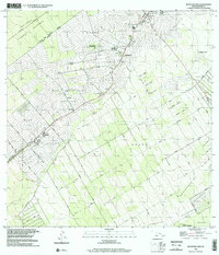 1994 Mountain View2002 Print · USGSThe Puna District comes into focus during the mid-nineties as traditional plantation camps transition into modern residential communities. Genealogists and local historians can trace family locations near Mountain View, Elevenmile Homestead, and the historic Kea'au Camp.
 - 1995 Map of Pahoa North, 2000 Print
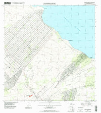 1995 Pahoa North2000 Print · USGSThe Puna coastline in the late nineties shows a landscape defined by expansive residential grids and volcanic history. Researchers can trace the path of the Lava Flow of 1840 and locate coastal landmarks like Honolulu Landing and the Makuu (Site).
End of results
Showing maps 1-2 of 2
Top cities near Ainaloa
Top neighborhoods of Ainaloa
Frequently asked questions
- What are the different types of historical maps available for Ainaloa?
- What is the oldest map of Ainaloa?
- Where can I purchase historical maps of Ainaloa for my home or office?
- Where can I download high-res historical maps of Ainaloa?
- Are there historical topographic maps available for Ainaloa?
- Is there historical aerial imagery available for Ainaloa?
- Where are historical maps of Ainaloa sourced from?