1960s Maps of Waa Waa, Hawaiian Beaches
Explore 2 historic maps of Waa Waa from the 1960s. These maps offer a rare glimpse into what life looked like during the 1960s — showing old roads, neighborhoods, homes, and landmarks that have changed or disappeared over time.
Whether you're researching your family's past, planning a metal detecting trip, or studying how Waa Waa's landscape evolved across the 1960s, these high-resolution maps are a powerful tool for exploring the history of this region.
- Focus on a specific era: All maps on this page are from the 1960s, giving you a focused view of this time period.
- See what’s changed: Compare century-old streets, trails, and buildings to today's modern landscape using overlays and satellite layers.
- Research with precision: Use these maps for genealogy, historical research, land use analysis, or educational projects.
- View, download, or print: Maps are fully viewable online in high resolution, and can be downloaded or printed for your own records.
Start exploring Waa Waa's history through authentic maps from the 1960s. This is your window into the past.
Waa Waa, Hawaiian Beaches maps
(2)- 1961 Map of Hawaii North
 1961 Hawaii North1961 Print · USGSThe Big Island's northern reaches are shown here in the early sixties, during the peak of the sugar era and before modern resort development. Researchers can trace the Hawaii Consolidated railroad, locate the Ahu a Umi Heiau Ruins, and explore sugar industry landmarks like the Pacific Sugar Mill.2 unique versions available
 - 1965 Map of Kapoho, 1967 Print
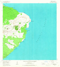 1965 Kapoho1967 Print · USGSThe Puna District coastline is captured here in the mid-1960s, showing a landscape recently transformed by volcanic eruptions. Researchers can locate ancient cultural sites like Mahinaakaka Heiau alongside newer landmarks like the Kapoho Landing Strip and Isaac Hale Park.
End of results
Showing maps 1-2 of 2
Top cities near Waa Waa
Frequently asked questions
- What are the different types of historical maps available for Waa Waa?
- What is the oldest map of Waa Waa?
- Where can I purchase historical maps of Waa Waa for my home or office?
- Where can I download high-res historical maps of Waa Waa?
- Are there historical topographic maps available for Waa Waa?
- Is there historical aerial imagery available for Waa Waa?
- Where are historical maps of Waa Waa sourced from?