1980s Maps of Hilo, Hawaii
Explore 5 historic maps of Hilo from the 1980s. These maps offer a rare glimpse into what life looked like during the 1980s — showing old roads, neighborhoods, homes, and landmarks that have changed or disappeared over time.
Whether you're researching your family's past, planning a metal detecting trip, or studying how Hilo's landscape evolved across the 1980s, these high-resolution maps are a powerful tool for exploring the history of this region.
- Focus on a specific era: All maps on this page are from the 1980s, giving you a focused view of this time period.
- See what’s changed: Compare century-old streets, trails, and buildings to today's modern landscape using overlays and satellite layers.
- Research with precision: Use these maps for genealogy, historical research, land use analysis, or educational projects.
- View, download, or print: Maps are fully viewable online in high resolution, and can be downloaded or printed for your own records.
Start exploring Hilo's history through authentic maps from the 1980s. This is your window into the past.
Hilo, HI maps
(5)- 1980 Map of Keaau Ranch, 1981 Print
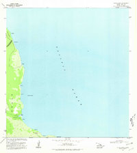 1980 Keaau Ranch1981 Print · USGSThe Puna coastline of Hawaii Island is shown here in the early 1980s, highlighting the remote settlements and ranch lands of the eastern shore. Researchers can trace the rugged shoreline from Kaloli Point to Anapuka, locating family-named sites like Keaau Ranch and Wahine Maka Nui.
 - 1980 Map of Hawaii County Sheet 2, 1985 Print
 1980 Hawaii County Sheet 21985 Print · USGSThe eastern coast of the Big Island is captured here in the early eighties, showcasing the intersection of active volcanic landforms and historic plantation towns. Researchers can trace family roots through settlements like Laupahoehoe and Papaikou, or explore the road networks around Kilauea Crater and General Lyman Field.
 - 1981 Map of Piihonua
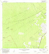
 1981 Piihonua1981 Print · USGSThe Hilo district in the early eighties shows the intersection of volcanic history and early island settlement. Researchers can trace the Lava Flow of 1881 past the Kaumana Cem or locate old waterworks like the Olaa Flume Spring.2 unique versions available
 - 1981 Map of Puu Makaala
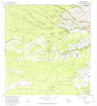
 1981 Puu Makaala1981 Print · USGSThe upland forests of Hawaii's Big Island are captured here in the early eighties, showing the transition from wild reserves to homesteads. Researchers can trace the Old Railroad Grade or locate early rural infrastructure like the Olaa Homestead Road and Stainback Highway.
 - 1981 Map of Hilo
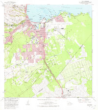 1981 Hilo1981 Print · USGSCoastal Hawaii comes into focus in the early eighties as Hilo transitions from its plantation roots to a modern regional hub. Researchers can trace family history through Homelani Memorial Park or locate industrial sites like the Puna Sugar Company Mill.2 unique versions available
End of results
Showing maps 1-5 of 5
Top cities near Hilo
Top neighborhoods of Hilo
- Kaumana historical maps
- Keaukaha historical maps
- Mokaoku historical maps
- Waiākea historical maps
- Piʻihonua historical maps
- Waiakea Hawaiian Home Land historical maps
See more
Frequently asked questions
- What are the different types of historical maps available for Hilo?
- What is the oldest map of Hilo?
- Where can I purchase historical maps of Hilo for my home or office?
- Where can I download high-res historical maps of Hilo?
- Are there historical topographic maps available for Hilo?
- Is there historical aerial imagery available for Hilo?
- Where are historical maps of Hilo sourced from?