1960s Maps of Papaikou, Hawaii
Explore 2 historic maps of Papaikou from the 1960s. These maps offer a rare glimpse into what life looked like during the 1960s — showing old roads, neighborhoods, homes, and landmarks that have changed or disappeared over time.
Whether you're researching your family's past, planning a metal detecting trip, or studying how Papaikou's landscape evolved across the 1960s, these high-resolution maps are a powerful tool for exploring the history of this region.
- Focus on a specific era: All maps on this page are from the 1960s, giving you a focused view of this time period.
- See what’s changed: Compare century-old streets, trails, and buildings to today's modern landscape using overlays and satellite layers.
- Research with precision: Use these maps for genealogy, historical research, land use analysis, or educational projects.
- View, download, or print: Maps are fully viewable online in high resolution, and can be downloaded or printed for your own records.
Start exploring Papaikou's history through authentic maps from the 1960s. This is your window into the past.
Papaikou, HI maps
(2)- 1961 Map of Hawaii North
 1961 Hawaii North1961 Print · USGSThe Big Island's northern reaches are shown here in the early sixties, during the peak of the sugar era and before modern resort development. Researchers can trace the Hawaii Consolidated railroad, locate the Ahu a Umi Heiau Ruins, and explore sugar industry landmarks like the Pacific Sugar Mill.2 unique versions available
 - 1966 Map of Papaikou, 1967 Print
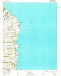 1966 Papaikou1967 Print · USGSThe Hamakua Coast of Hawaii Island is shown here during the height of the plantation era, characterized by coastal sugar mills and upland flumes. Local historians can trace the development of Pepeekeo Mill and the specific boundaries of Kulaimano Homesteads and Kaieie Homesteads.
End of results
Showing maps 1-2 of 2
Top cities near Papaikou
Top neighborhoods of Papaikou
Frequently asked questions
- What are the different types of historical maps available for Papaikou?
- What is the oldest map of Papaikou?
- Where can I purchase historical maps of Papaikou for my home or office?
- Where can I download high-res historical maps of Papaikou?
- Are there historical topographic maps available for Papaikou?
- Is there historical aerial imagery available for Papaikou?
- Where are historical maps of Papaikou sourced from?