1950s Maps of Kalihi, Honolulu
Explore 3 historic maps of Kalihi from the 1950s. These maps offer a rare glimpse into what life looked like during the 1950s — showing old roads, neighborhoods, homes, and landmarks that have changed or disappeared over time.
Whether you're researching your family's past, planning a metal detecting trip, or studying how Kalihi's landscape evolved across the 1950s, these high-resolution maps are a powerful tool for exploring the history of this region.
- Focus on a specific era: All maps on this page are from the 1950s, giving you a focused view of this time period.
- See what’s changed: Compare century-old streets, trails, and buildings to today's modern landscape using overlays and satellite layers.
- Research with precision: Use these maps for genealogy, historical research, land use analysis, or educational projects.
- View, download, or print: Maps are fully viewable online in high resolution, and can be downloaded or printed for your own records.
Start exploring Kalihi's history through authentic maps from the 1950s. This is your window into the past.
Kalihi, Honolulu maps
(3)- 1953 Map of Honolulu, 1956 Print
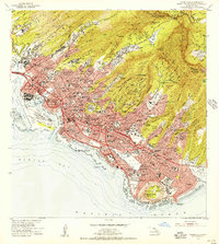 1953 Honolulu1956 Print · USGSMid-century Honolulu is captured here during a time of rapid urban expansion, from the bustling waterfront to the residential ridges. Researchers can trace the footprints of Fort Shafter, the historic Oahu Railway, and the early layout of the University of Hawaii.
 - 1954 Map of Oahu
 1954 Oahu1954 Print · USGSMid-century Oahu is caught between its plantation roots and its growing role as a Pacific military hub. Trace the OR and L Co rail lines and explore the 1950s footprints of Pearl Harbor, Libbyville, and Waipahu.
 - 1959 Map of Honolulu, 1961 Print
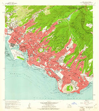 1959 Honolulu1961 Print · USGSMid-century Honolulu is captured here during a transition toward modern statehood, showing a dense city bounded by the Koolau peaks and the Pacific. Trace the footprints of the Oahu Railway and Land Co, Iolani Palace, and Diamond Head.
End of results
Showing maps 1-3 of 3
Frequently asked questions
- What are the different types of historical maps available for Kalihi?
- What is the oldest map of Kalihi?
- Where can I purchase historical maps of Kalihi for my home or office?
- Where can I download high-res historical maps of Kalihi?
- Are there historical topographic maps available for Kalihi?
- Is there historical aerial imagery available for Kalihi?
- Where are historical maps of Kalihi sourced from?