1900s (20th Century) Maps of Mānoa, Honolulu
Explore 10 historic maps of Mānoa from the 1900s (20th Century). These maps offer a rare glimpse into what life looked like during the 1900s — showing old roads, neighborhoods, homes, and landmarks that have changed or disappeared over time.
Whether you're researching your family's past, planning a metal detecting trip, or studying how Mānoa's landscape evolved across the 1900s, these high-resolution maps are a powerful tool for exploring the history of this region.
- Focus on a specific era: All maps on this page are from the 1900s, giving you a focused view of this time period.
- See what’s changed: Compare century-old streets, trails, and buildings to today's modern landscape using overlays and satellite layers.
- Research with precision: Use these maps for genealogy, historical research, land use analysis, or educational projects.
- View, download, or print: Maps are fully viewable online in high resolution, and can be downloaded or printed for your own records.
Start exploring Mānoa's history through authentic maps from the 1900s. This is your window into the past.
Mānoa, Honolulu maps
(10)- 1953 Map of Honolulu, 1956 Print
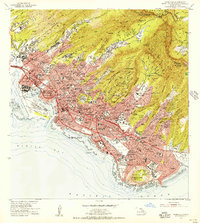 1953 Honolulu1956 Print · USGSMid-century Honolulu is captured here during a time of rapid urban expansion, from the bustling waterfront to the residential ridges. Researchers can trace the footprints of Fort Shafter, the historic Oahu Railway, and the early layout of the University of Hawaii.
 - 1954 Map of Oahu
 1954 Oahu1954 Print · USGSMid-century Oahu is caught between its plantation roots and its growing role as a Pacific military hub. Trace the OR and L Co rail lines and explore the 1950s footprints of Pearl Harbor, Libbyville, and Waipahu.
 - 1959 Map of Honolulu, 1961 Print
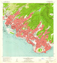 1959 Honolulu1961 Print · USGSMid-century Honolulu is captured here during a transition toward modern statehood, showing a dense city bounded by the Koolau peaks and the Pacific. Trace the footprints of the Oahu Railway and Land Co, Iolani Palace, and Diamond Head.
 - 1961 Map of Oahu
 1961 Oahu1961 Print · USGSOahu's strategic landscape is captured here during the early statehood era, showing the balance between burgeoning urban centers and massive military installations. Trace the path of the Oahu Railway and Land Co or locate historical sites like Schofield Barracks and Punchbowl Hill.
 - 1965 Map of Oahu
 1965 Oahu1965 Print · USGSOahu in the mid-sixties reveals a landscape defined by significant military installations and growing coastal communities. Researchers can trace the infrastructure of Pearl Harbor, Schofield Barracks, and landmarks like Diamond Head.2 unique versions available
 - 1969 Map of Honolulu, 1971 Print
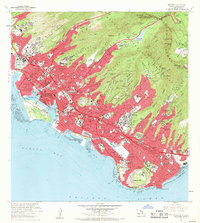 1969 Honolulu1971 Print · USGSIn the late 1960s, Honolulu’s modern skyline was rising against the backdrop of ancient volcanic craters and steep emerald ridges. Researchers can trace the mid-century city layout, identifying landmarks like Diamond Head, the Punchbowl, and the Aloha Tower.2 unique versions available
 - 1970 Map of Oahu, 1973 Print
 1970 Oahu1973 Print · USGSOahu was entering a new era of suburban and military expansion in the early seventies. Trace the growth of Mililani Town and Pearl City, or locate historic sites like Schofield Barracks and Diamond Head State Monument.2 unique versions available
 - 1978 Map of Honolulu, 1981 Print
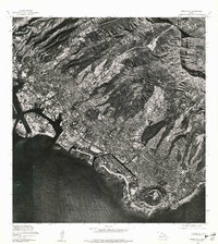 1978 Honolulu1981 Print · USGSThe city of Honolulu is captured in sharp aerial detail during the mid-seventies, showing the urban landscape from the harbor to the mountains. Researchers can trace development patterns around the iconic DIAMOND HEAD crater and the heights of KONAHUANUI.
 - 1983 Map of Honolulu, 1986 Print
 1983 Honolulu1986 Print · USGSHonolulu in the early eighties shows a dense urban sprawl climbing into the volcanic ridges of the Koolau Range. Genealogists and historians can trace the footprints of Kamehameha Schools, Punahou School, and landmark cemeteries like Oahu Cem.
 - 1998 Map of Honolulu, 2000 Print
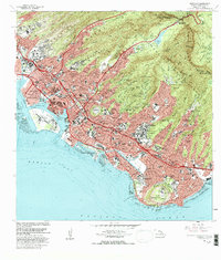
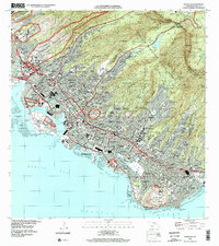 1998 Honolulu2000 Print · USGSHonolulu is captured in the late nineties, showcasing the city's unique geography where volcanic craters like Diamond Head meet a sprawling urban grid. Genealogists and historians can trace institutional landmarks and local neighborhoods from the Royal Mausoleum and Oahu Cemetery to Alewa Heights and Waialae.
End of results
Showing maps 1-10 of 10
Frequently asked questions
- What are the different types of historical maps available for Mānoa?
- What is the oldest map of Mānoa?
- Where can I purchase historical maps of Mānoa for my home or office?
- Where can I download high-res historical maps of Mānoa?
- Are there historical topographic maps available for Mānoa?
- Is there historical aerial imagery available for Mānoa?
- Where are historical maps of Mānoa sourced from?