1950s Maps of Kaneohe, Hawaii
Explore 5 historic maps of Kaneohe from the 1950s. These maps offer a rare glimpse into what life looked like during the 1950s — showing old roads, neighborhoods, homes, and landmarks that have changed or disappeared over time.
Whether you're researching your family's past, planning a metal detecting trip, or studying how Kaneohe's landscape evolved across the 1950s, these high-resolution maps are a powerful tool for exploring the history of this region.
- Focus on a specific era: All maps on this page are from the 1950s, giving you a focused view of this time period.
- See what’s changed: Compare century-old streets, trails, and buildings to today's modern landscape using overlays and satellite layers.
- Research with precision: Use these maps for genealogy, historical research, land use analysis, or educational projects.
- View, download, or print: Maps are fully viewable online in high resolution, and can be downloaded or printed for your own records.
Start exploring Kaneohe's history through authentic maps from the 1950s. This is your window into the past.
Kaneohe, HI maps
(5)- 1952 Map of Mokapu, 1954 Print
 1952 Mokapu1954 Print · USGSWindward Oahu's coastline is captured in the early fifties, showing the development of Kailua and Lanikai alongside major military installations. Genealogists and historians can trace local landmarks like the Heiau, Kailua Sky Ranch, and the Koolau Boys Home.
 - 1954 Map of Oahu
 1954 Oahu1954 Print · USGSMid-century Oahu is caught between its plantation roots and its growing role as a Pacific military hub. Trace the OR and L Co rail lines and explore the 1950s footprints of Pearl Harbor, Libbyville, and Waipahu.
 - 1954 Map of Kaneohe, 1956 Print
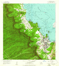
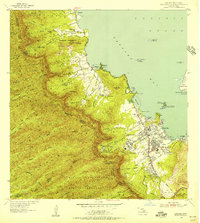 1954 Kaneohe1956 Print · USGSWindward Oahu in the mid-fifties shows a landscape of mountain homesteads and expanding coastal settlements. Trace family land in the Waiahole Homesteads or locate local landmarks like the Territorial Hospital and the Heeia Radio Station.
 - 1959 Map of Mokapu, 1960 Print
 1959 Mokapu1960 Print · USGSCoastal Oahu at the dawn of the 1960s reveals a mix of military installations and burgeoning seaside communities. Local historians can trace the early layouts of Lanikai and Kailua, alongside landmarks like the Kailua Sky Ranch and Bellows Air Force Base.2 unique versions available
 - 1959 Map of Kaneohe, 1961 Print
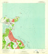
 1959 Kaneohe1961 Print · USGSCoastal Oahu in the late fifties shows a mix of growing residential communities and traditional Hawaiian fishponds. Genealogists and historians can trace family roots through the Kokokahi Homesteads, locate old landmarks like St Anns Sch, or study the footprint of the State Hospital.
End of results
Showing maps 1-5 of 5
Top cities near Kaneohe
- Honolulu historical maps
- Waipahu historical maps
- East Honolulu historical maps
- Mililani historical maps
- Pearl City historical maps
- Kailua historical maps
See more
Top neighborhoods of Kaneohe
- Puohala historical maps
- Kapunahala historical maps
- Keapuka historical maps
- Mahinui historical maps
- Māla‘e historical maps
- Pū‘ōhala Village historical maps
See more
Frequently asked questions
- What are the different types of historical maps available for Kaneohe?
- What is the oldest map of Kaneohe?
- Where can I purchase historical maps of Kaneohe for my home or office?
- Where can I download high-res historical maps of Kaneohe?
- Are there historical topographic maps available for Kaneohe?
- Is there historical aerial imagery available for Kaneohe?
- Where are historical maps of Kaneohe sourced from?