1960s Maps of Kaneohe, Hawaii
Explore 4 historic maps of Kaneohe from the 1960s. These maps offer a rare glimpse into what life looked like during the 1960s — showing old roads, neighborhoods, homes, and landmarks that have changed or disappeared over time.
Whether you're researching your family's past, planning a metal detecting trip, or studying how Kaneohe's landscape evolved across the 1960s, these high-resolution maps are a powerful tool for exploring the history of this region.
- Focus on a specific era: All maps on this page are from the 1960s, giving you a focused view of this time period.
- See what’s changed: Compare century-old streets, trails, and buildings to today's modern landscape using overlays and satellite layers.
- Research with precision: Use these maps for genealogy, historical research, land use analysis, or educational projects.
- View, download, or print: Maps are fully viewable online in high resolution, and can be downloaded or printed for your own records.
Start exploring Kaneohe's history through authentic maps from the 1960s. This is your window into the past.
Kaneohe, HI maps
(4)- 1961 Map of Oahu
 1961 Oahu1961 Print · USGSOahu's strategic landscape is captured here during the early statehood era, showing the balance between burgeoning urban centers and massive military installations. Trace the path of the Oahu Railway and Land Co or locate historical sites like Schofield Barracks and Punchbowl Hill.
 - 1965 Map of Oahu
 1965 Oahu1965 Print · USGSOahu in the mid-sixties reveals a landscape defined by significant military installations and growing coastal communities. Researchers can trace the infrastructure of Pearl Harbor, Schofield Barracks, and landmarks like Diamond Head.2 unique versions available
 - 1968 Map of Mokapu, 1970 Print
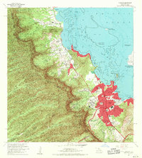
 1968 Mokapu1970 Print · USGSCoastal Oahu in the late sixties reveals a mix of expanding suburbs and significant military installations along the Windward shore. Local researchers can trace residential growth in Kailua, explore the Kawainui Swamp basin, or locate landmarks like Ulupau Crater and St Anthony Sch.2 unique versions available
 - 1968 Map of Kaneohe, 1970 Print
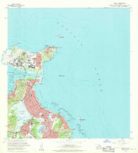
 1968 Kaneohe1970 Print · USGSWindward Oahu's coastline and valleys are captured here in the late sixties as traditional homesteads and modern developments meet. Trace family roots and land use through the Waiahole Homesteads, the Byodo-In Temple, and Puohala Village.2 unique versions available
End of results
Showing maps 1-4 of 4
Top cities near Kaneohe
- Honolulu historical maps
- Waipahu historical maps
- East Honolulu historical maps
- Mililani historical maps
- Pearl City historical maps
- Kailua historical maps
See more
Top neighborhoods of Kaneohe
- Puohala historical maps
- Kapunahala historical maps
- Keapuka historical maps
- Mahinui historical maps
- Māla‘e historical maps
- Pū‘ōhala Village historical maps
See more
Frequently asked questions
- What are the different types of historical maps available for Kaneohe?
- What is the oldest map of Kaneohe?
- Where can I purchase historical maps of Kaneohe for my home or office?
- Where can I download high-res historical maps of Kaneohe?
- Are there historical topographic maps available for Kaneohe?
- Is there historical aerial imagery available for Kaneohe?
- Where are historical maps of Kaneohe sourced from?