1900s (20th Century) Maps of Kaʻeleku, Maui County
Explore 7 historic maps of Kaʻeleku from the 1900s (20th Century). These maps offer a rare glimpse into what life looked like during the 1900s — showing old roads, neighborhoods, homes, and landmarks that have changed or disappeared over time.
Whether you're researching your family's past, planning a metal detecting trip, or studying how Kaʻeleku's landscape evolved across the 1900s, these high-resolution maps are a powerful tool for exploring the history of this region.
- Focus on a specific era: All maps on this page are from the 1900s, giving you a focused view of this time period.
- See what’s changed: Compare century-old streets, trails, and buildings to today's modern landscape using overlays and satellite layers.
- Research with precision: Use these maps for genealogy, historical research, land use analysis, or educational projects.
- View, download, or print: Maps are fully viewable online in high resolution, and can be downloaded or printed for your own records.
Start exploring Kaʻeleku's history through authentic maps from the 1900s. This is your window into the past.
Kaʻeleku, Maui County maps
(7)- 1954 Map of Maui
 1954 Maui1954 Print · USGSThe central Hawaiian Islands are shown during the mid-fifties, detailing the agricultural and coastal infrastructure of Maui, Lanai, and Molokai. Genealogists and researchers can trace plantation-era history at Haliimaile Camp, locate old harbors like Kaumalapau Harbor, or explore the early bounds of Haleakala National Park.
 - 1957 Map of Hana, 1959 Print
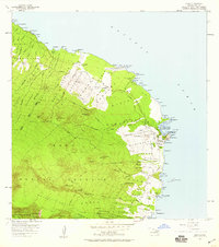 1957 Hana1959 Print · USGSEast Maui comes to life in the late fifties as the modern highway begins to link traditional coastal homesteads. Genealogists and researchers can trace family-named landmarks and settlements from Hana to Mokae Landing, plus cultural sites like the Heiau near Kalahu Point.2 unique versions available
 - 1966 Map of Maui
 1966 Maui1966 Print · USGSThe central islands of Maui, Molokai, Lanai, and Kahoolawe are shown in detail during the mid-1960s as plantation life and early tourism coexisted. Genealogists and researchers can trace family locations in old plantation towns like Puunene, the harbor at Lahaina, and Hoolehua on Molokai.
 - 1974 Map of Maui
 1974 Maui1974 Print · USGSMid-century Hawaii is captured here through the detailed landscapes of Maui, Molokai, Lanai, and Kahoolawe as they appeared in the 1970s. Researchers can trace the layout of island hubs like Lahaina and Lanai City alongside remote landmarks like Wainapanapa Cave.2 unique versions available
 - 1978 Map of Hana, 1981 Print
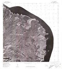 1978 Hana1981 Print · USGSEast Maui in the late seventies is seen through aerial photography, showing the coastal community and its volcanic surroundings. Researchers can trace the layout of Hana and find natural landmarks like Keakulikuli Pt. and Puu Hinai.
 - 1983 Map of Hana, 1984 Print
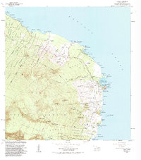 1983 Hana1984 Print · USGSCoastal East Maui during the early eighties shows a landscape of traditional homesteads and developing infrastructure. Genealogists and researchers can trace local landmarks from Hana to Hamoa, including Mokae Landing and the Hana High School.
 - 1992 Map of Hana, 2002 Print
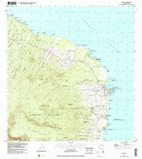 1992 Hana2002 Print · USGSThe Hāna coast of Maui appeared as a blend of traditional homesteads and coastal villages in the early nineties. Researchers can trace land divisions like the Nāhiku Homesteads and find local landmarks such as the Hāna High and Elementary School or Mokae Landing (Site).
End of results
Showing maps 1-7 of 7
Frequently asked questions
- What are the different types of historical maps available for Kaʻeleku?
- What is the oldest map of Kaʻeleku?
- Where can I purchase historical maps of Kaʻeleku for my home or office?
- Where can I download high-res historical maps of Kaʻeleku?
- Are there historical topographic maps available for Kaʻeleku?
- Is there historical aerial imagery available for Kaʻeleku?
- Where are historical maps of Kaʻeleku sourced from?