Old Maps of Maui County, Hawaii
Explore 208 old maps of Maui County, spanning from 1923 to today. These high-resolution historic maps reveal how streets, neighborhoods, landmarks, and natural features evolved over time — perfect for genealogy, metal detecting, research, and local history exploration.
What you can do with these maps:
- See how Maui County changed over time: Compare historical maps to modern-day views to trace roads, homesites, rail lines & more.
- View detailed metadata: Each map includes creators, publishers, year, scale, and archive source.
- Overlay maps with satellite & LiDAR: Visualize the past alongside modern tools to explore terrain & human change.
- Trusted historical sources: Maps sourced from the USGS, Library of Congress, and other archives.
- Access maps your way: View online, download high-res files, or order prints for personal or research use.
Start exploring old maps of Maui County to uncover forgotten places, hidden landmarks, and the deep history beneath your feet.
Maui County, HI maps
(208)- 1923 Map of Island of Lanai
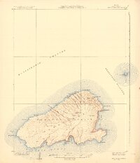
 1923 Island of Lanai1923 Print · USGSLanai in the early twenties reveals a landscape of deep gulches and emerging inland settlement just as the pineapple era began. Trace coastal landmarks like Keomuku PO and Halepalaoa Landing or explore the harbor at Kaumalapau Harbor.2 unique versions available
 - 1925 Map of Island of Lanai
 1925 Island of Lanai1925 Print · USGSLanai is mapped here during the mid-twenties, showing the island's transition into a centralized plantation economy. Genealogists and historians can trace the early layout of Lanai City, the coastal Keomuku P O, and the ancient Kaa Fishpond.
 - 1929 Map of Kahoolawe
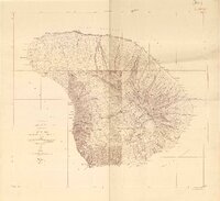
 1929 Kahoolawe1929 Print · USGSKahoolawe and the surrounding channels are depicted in detail during the late 1920s, showing the island's topography while it was still part of the territorial ranching era. Researchers can trace landforms and landmarks like the Heiau, the crater Lua Makika, and the Molokini islet.3 unique versions available
 - 1952 Map of Halawa, 1953 Print
 1952 Halawa1953 Print · USGSEastern Molokai in the early fifties maintains its traditional character, from ancient fishponds to highland forest reserves. Trace ancestral land divisions and sacred sites like the Iliiliopae Heiau alongside coastal landmarks such as Halawa and Pukoo Fishpond.
 - 1952 Map of Molokai Airport, 1954 Print
 1952 Molokai Airport1954 Print · USGSMolokai’s central plateau and southwestern slopes are captured here in the early fifties, featuring the transition from homesteaded grids to open volcanic terrain. Researchers can trace land divisions at Hoolehua Homesteads and find old landmarks like Kolo Wharf and Puu Nana.
 - 1952 Map of Kamalo, 1954 Print
 1952 Kamalo1954 Print · USGSThe southern shore of Molokai and its dramatic northern valleys are documented here just after mid-century. Genealogists and historians can locate several ancient temples such as Kukui Heiau, the Hukoo PO at Ualapue, and remote north-coast sites like Wailau (Site).
 - 1952 Map of Ilio Point, 1954 Print
 1952 Ilio Point1954 Print · USGSMolokai’s west end is captured in the early fifties, showing a land of deep gulches and significant military reservations. Researchers can locate the Mauna Loa Cem, trace the extensive Papohaku Beach, and identify the Kamakalipo (Site).
 - 1952 Map of Kaunakakai, 1954 Print
 1952 Kaunakakai1954 Print · USGSThe central and northern coasts of Molokai are documented here in the early fifties, featuring the isolated Kalaupapa Settlement and the hub of Kaunakakai. Genealogists can trace family plots and local landmarks like Hoolehua Cem and the Hoolehua Homesteads.
 - 1954 Map of Maui
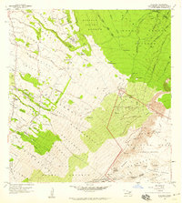
 1954 Maui1954 Print · USGSThe central Hawaiian Islands are shown during the mid-fifties, detailing the agricultural and coastal infrastructure of Maui, Lanai, and Molokai. Genealogists and researchers can trace plantation-era history at Haliimaile Camp, locate old harbors like Kaumalapau Harbor, or explore the early bounds of Haleakala National Park.
 - 1954 Map of Maalaea, 1956 Print
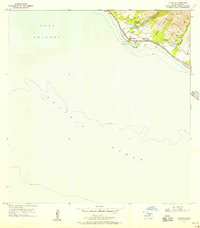
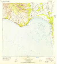 1954 Maalaea1956 Print · USGSMaui's central coastline in the mid-fifties reveals an island landscape defined by traditional homesteads and developing aviation infrastructure. Genealogists and historians can locate early settlements at Kihei and the Waikapu Homesteads, alongside the Old Maui Airport and the Kealia Pond wetlands.2 unique versions available
 - 1954 Map of Paia, 1956 Print
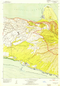
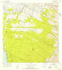
 1954 Paia1956 Print · USGSIn the mid-fifties, the sugar plantation landscape of central Maui was a dense network of worker communities and industrial rail. Genealogists and historians can trace specific residential enclaves like Japanese Village 1, Russian Village, and Alabama Village near the Puunene mills.2 unique versions available
 - 1954 Map of Puu O Kali, 1956 Print
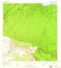
 1954 Puu O Kali1956 Print · USGSMaui's leeward slopes are captured in the mid-fifties, showing a detailed network of residential homesteads and sugar-era camps. Genealogists can trace early properties in the Waiakoa Homesteads or locate family sites near Puu Hale Cemetery and Camp K-3.2 unique versions available
 - 1954 Map of Makena, 1956 Print
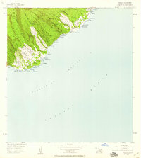
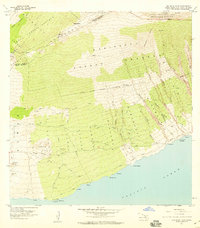
 1954 Makena1956 Print · USGSCoastal Maui in the mid-fifties reveals a landscape of ranching outposts, traditional land divisions, and remote shorelines. Genealogists and historians can trace family sites at Ulupalakua Ranch, Keawalai Church, and the Ulupalakua School.3 unique versions available
 - 1955 Map of Olowalu, 1957 Print
 1955 Olowalu1957 Print · USGSCoastal Maui in the mid-fifties shows a landscape defined by sugar ruins and sacred Hawaiian sites along the leeward shore. Researchers can locate the Mill (Ruins), trace the irrigation network of Ukumehame Reservoirs, and find Kaiwaloa Heiau.2 unique versions available
 - 1955 Map of Wailuku, 1957 Print
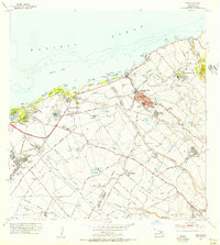
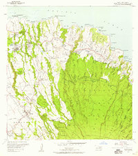
 1955 Wailuku1957 Print · USGSMaui in the mid-fifties shows a bustling plantation and civic hub as Wailuku expands and the sugar industry thrives. Genealogists and researchers can trace local landmarks like Baldwin High School, the Kahului Railroad, and worker housing at Ah Fong Village or McGerrow Village.2 unique versions available
 - 1955 Map of Kahakuloa, 1957 Print
 1955 Kahakuloa1957 Print · USGSCoastal Maui in the mid-fifties reveals a landscape of deep gulches and remote homesteads along the windward shore. Genealogists and historians can trace the early layout of Kahakuloa village, the Kahakuloa Homesteads, and the footprint of Maluhia Camp.
 - 1956 Map of Lahaina, 1959 Print
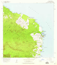
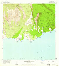
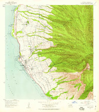 1956 Lahaina1959 Print · USGSCoastal Maui in the mid-fifties is defined by its bustling sugar and pineapple industries and complex water networks. Genealogists and historians can trace the foundations of Lahaina through the Sugar Mill, Hanakaöo Cemetery, and Lahainaluna High School.2 unique versions available
 - 1956 Map of Honolua, 1959 Print
 1956 Honolua1959 Print · USGSNorthwest Maui in the mid-fifties reveals a coastal landscape of plantation-era settlements and ancient sites before the rise of major resorts. Genealogists and historians can trace Honokahua PO, the Heakalani Heiau, and family land divisions across the West Maui Forest Reserve.3 unique versions available
 - 1957 Map of Kilohana, 1959 Print
 1957 Kilohana1959 Print · USGSMaui in the late fifties reveals a high-altitude landscape of homesteads and early scientific research on the slopes of the mountain. Trace the development of the Kula Homesteads and find historic sites like the Olinda Prison Camp or the Silversword Inn.2 unique versions available
 - 1957 Map of Kipahulu, 1959 Print
 1957 Kipahulu1959 Print · USGSMaui's southeastern coast comes to life in this mid-century survey, from the high ridges to the shore. Researchers can trace historic sites like Kapekuua Heiau, the Old Landing at Maulili Bay, and family-named points such as Kakanoni Pt.2 unique versions available
 - 1957 Map of Hana, 1959 Print
 1957 Hana1959 Print · USGSEast Maui comes to life in the late fifties as the modern highway begins to link traditional coastal homesteads. Genealogists and researchers can trace family-named landmarks and settlements from Hana to Mokae Landing, plus cultural sites like the Heiau near Kalahu Point.2 unique versions available
 - 1957 Map of Haiku, 1959 Print
 1957 Haiku1959 Print · USGSCoastal Maui in the late fifties shows a landscape shaped by sugar plantation infrastructure and small rural communities. Genealogists and historians can trace worker settlements like Filipino Camp, locate the Haiku School, and follow the old Hana Highway corridor.3 unique versions available
 - 1957 Map of Lualailua Hills, 1959 Print
 1957 Lualailua Hills1959 Print · USGSMaui's southern coastline and volcanic slopes are captured here in the mid-fifties, showing the transition from forest reserves to the sea. Trace the rugged terrain through Haleakala National Park, Kahikinui House, and the distinct Lualailua Hills.2 unique versions available
 - 1957 Map of Nahiku, 1959 Print
 1957 Nahiku1959 Print · USGSThe northeastern coast of Maui is captured here in the late fifties, showing the winding Hana Highway and the remote Nahiku Homesteads. Researchers can trace the water infrastructure of the Koolau Forest Reserve or locate high-elevation landmarks like Waikau Cabin and the Cemetery near Honolulunui Bay.2 unique versions available
 - 1957 Map of Kaupo, 1959 Print
 1957 Kaupo1959 Print · USGSThe remote southern coast of Maui is captured in the late fifties as a landscape of traditional homesteads and ancient Hawaiian sites. Genealogists and historians can trace the Kaupo Homesteads and locate significant landmarks like Loaloa Heiau and the Nuu (Site).2 unique versions available
Showing maps 1-25 of 208
Top cities of Maui County
- Kahului historical maps
- Wailuku historical maps
- Lahaina historical maps
- Pukalani historical maps
- Kaunakakai historical maps
- Lanai City historical maps
See more
Frequently asked questions
- What are the different types of historical maps available for Maui County?
- What is the oldest map of Maui County?
- Where can I purchase historical maps of Maui County for my home or office?
- Where can I download high-res historical maps of Maui County?
- Are there historical topographic maps available for Maui County?
- Is there historical aerial imagery available for Maui County?
- Where are historical maps of Maui County sourced from?