
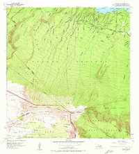
1957 Map of Nahiku
USGS Topo · Published 1959About this map
The coastal settlement of Nahiku and the surrounding Nahiku Homesteads mark the northeastern edge of this mid-century survey, where the Hana Highway winds across a series of steep gulches. This landscape is defined by the transition from the fertile slopes of the Koolau Forest Reserve down to the Pacific shoreline at Waiohue Bay and Honolulunui Bay. Further inland, the terrain rises sharply toward the volcanic wonders of Haleakala National Park, featuring the prominent Koolau Gap and the high Kalapawili Ridge. Evidence of early 20th-century water management is visible throughout the forest reserves, with a network of Wells, Pump stations, and a Pipeline feeding into the local infrastructure. Remote shelters like Waikau Cabin and Paliku Cabin provide points of reference for those navigating the high country above Kipahulu Valley, while the Cemetery near the coast offers a specific touchpoint for genealogical research in this rural Maui community.
Find a feature on this map
88 named features on this map. Tap any name to fly to it.
Don’t see what you’re looking for? This feature index may not catch every label — zoom into the map to look around manually.
Map Details
Editions of this 1957 Nahiku Map
2 editions found
Other maps of this area

1954 · Maui
USGS Topo · 1:250,000

1957 · Kilohana
USGS Topo · 1:24,000

1957 · Kipahulu
USGS Topo · 1:24,000

1957 · Hana
USGS Topo · 1:24,000

1957 · Haiku
USGS Topo · 1:24,000

1957 · Lualailua Hills
USGS Topo · 1:24,000

1957 · Kaupo
USGS Topo · 1:24,000

1957 · Keanae
USGS Topo · 1:24,000

1966 · Maui
USGS Topo · 1:250,000

1974 · Maui
USGS Topo · 1:250,000