
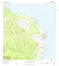
1957 Map of Hana
USGS Topo · Published 1959About this map
Hana and the east coast of Maui are depicted in this mid-century survey, showcasing a landscape transitioning from traditional homesteads to modern infrastructure. The Hana Highway snakes along the coastline, connecting established settlements like Kaeleku and Hamoa with the newly constructed Hana Airport. Along the shore, the map identifies cultural and physical landmarks such as Kauiki Head and Ka Iwi o Pele, alongside older habitation points marked as Ulaino (Site) and Honomale (Site).
Find a feature on this map
107 named features on this map. Tap any name to fly to it.
Don’t see what you’re looking for? This feature index may not catch every label — zoom into the map to look around manually.
Map Details
Editions of this 1957 Hana Map
2 editions found
Other maps of this area

1954 · Maui
USGS Topo · 1:250,000

1957 · Kipahulu
USGS Topo · 1:24,000

1957 · Nahiku
USGS Topo · 1:24,000

1957 · Kaupo
USGS Topo · 1:24,000

1957 · Keanae
USGS Topo · 1:24,000

1966 · Maui
USGS Topo · 1:250,000

1974 · Maui
USGS Topo · 1:250,000

1978 · Hana
USGS Topo · 1:24,000

1983 · Nahiku
USGS Topo · 1:24,000
1983 · Kaupo
USGS Topo · 1:24,000