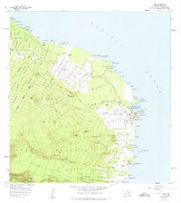
1957 Map of Hana
USGS Topo · Published 1974About this map
Hana and its surrounding coastal settlements are mapped here at the midpoint of the twentieth century, anchored by the deep indentation of Hana Bay and the prominent Kauiki Head. The landscape is a mosaic of land divisions and homesteads, including the Nahiku Homesteads and Kakio Homesteads, showing the organized agricultural and residential patterns of the era. An old railroad grade traces a path through the Wakiu and Honokalani districts, serving as a reminder of the region's plantation history when rail was vital for moving sugar or pineapple to the coast. Beyond the village, the Hana Forest Reserve and Haleakala National Park Kipahulu Forest Reserve rise into the clouds, dissected by numerous gulches like Honomaele Gulch and Moomooiki Gulch, which feed into the Pacific Ocean along a coastline dotted with distinctive points and landings.
Find a feature on this map
118 named features on this map. Tap any name to fly to it.
Don’t see what you’re looking for? This feature index may not catch every label — zoom into the map to look around manually.
Map Details
Editions of this 1957 Hana Map
2 editions found
Other maps of this area

1954 · Maui
USGS Topo · 1:250,000

1957 · Kipahulu
USGS Topo · 1:24,000

1957 · Hana
USGS Topo · 1:24,000

1957 · Nahiku
USGS Topo · 1:24,000

1957 · Kaupo
USGS Topo · 1:24,000

1957 · Keanae
USGS Topo · 1:24,000

1966 · Maui
USGS Topo · 1:250,000

1974 · Maui
USGS Topo · 1:250,000

1978 · Hana
USGS Topo · 1:24,000

1983 · Nahiku
USGS Topo · 1:24,000