1980s Maps of Maui County, Hawaii
Explore 20 historic maps of Maui County from the 1980s. These maps offer a rare glimpse into what life looked like during the 1980s — showing old roads, neighborhoods, homes, and landmarks that have changed or disappeared over time.
Whether you're researching your family's past, planning a metal detecting trip, or studying how Maui County's landscape evolved across the 1980s, these high-resolution maps are a powerful tool for exploring the history of this region.
- Focus on a specific era: All maps on this page are from the 1980s, giving you a focused view of this time period.
- See what’s changed: Compare century-old streets, trails, and buildings to today's modern landscape using overlays and satellite layers.
- Research with precision: Use these maps for genealogy, historical research, land use analysis, or educational projects.
- View, download, or print: Maps are fully viewable online in high resolution, and can be downloaded or printed for your own records.
Start exploring Maui County's history through authentic maps from the 1980s. This is your window into the past.
Maui County, HI maps
(20)- 1983 Map of Olowalu
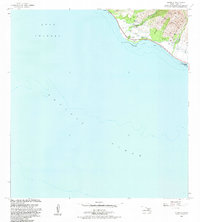 1983 Olowalu1983 Print · USGSCoastal Maui in the early eighties shows a transition from historical irrigation to modern recreation. Researchers can trace land use through the Olowalu Shaft, find the local Heiau, and locate the Olowalu Wharf along the shoreline.2 unique versions available
 - 1983 Map of Lualailua Hills
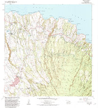
 1983 Lualailua Hills1983 Print · USGSThe southern slopes of Maui meet the sea in the early eighties, where protected forests descend toward a remote shoreline. Trace historic paths and isolated outposts like the Manukani Trail, Hokukano, and the Natural Arch at Pakowai.
 - 1983 Map of Nahiku
 1983 Nahiku1983 Print · USGSThe north coast of Maui meets the volcanic heights of Haleakala in the early 1980s. Trace the winding Hana Highway past Nahiku Homesteads or locate backcountry shelters like Kapaloa Cabin and Paliku Cabin.
 - 1983 Map of Maalaea
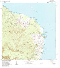
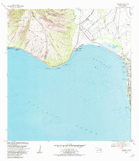 1983 Maalaea1983 Print · USGSThe shores of Maui are captured here in the early eighties, showing the critical junction between the West Maui mountains and the expansive bay. Local researchers can trace coastal developments from the Maalaea Small Boat Harbor to the inland Kealia Pond and the cemetery at Kihei.2 unique versions available
 - 1983 Map of Molokai East
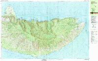 1983 Molokai East1983 Print · USGSEast Molokai in the early eighties reveals a striking contrast between the protected northern peninsula and the fishpond-lined southern shore. Researchers can trace historic sites like the Kalaupapa Settlement or locate traditional waters at Ualapue Fishpond and Kanoa Fishpond.2 unique versions available
 - 1983 Map of Kaupo
 1983 Kaupo1983 Print · USGSThe southern coast of Maui is captured here in the early eighties, showcasing a landscape defined by volcanic slopes and ancient Hawaiian sites. Researchers can trace land divisions at Kaupo Homesteads or locate cultural landmarks like Loaloa Heiau and the Nuu (Site).
 - 1983 Map of Kilohana
 1983 Kilohana1983 Print · USGSUpcountry Maui in the early eighties shows a unique blend of agricultural homesteads and the volcanic heights of the summit. Genealogists and hikers can trace the Haleakala Homesteads and find landmarks like Waiakoa or the Holua Cabin trail shelter.2 unique versions available
 - 1983 Map of Paia
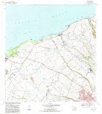 1983 Paia1983 Print · USGSThe northern coast of Maui during the early eighties reveals a landscape shaped by sugar production and coastal development. Genealogists and historians can trace the remnants of the Old Railroad Grade and locate specific sites like Spanish B Village, Maunaolu College, and the Sugar Mill at Puunene.
 - 1983 Map of Kipahulu
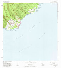 1983 Kipahulu1983 Print · USGSSoutheast Maui’s coast is captured in the early eighties as the Piilani Highway winds through ancient valley landscapes. Researchers can trace historic shorelines and cultural sites including a Historical Monument, Wailua Falls, and several native Heiau.2 unique versions available
 - 1983 Map of Kahakuloa
 1983 Kahakuloa1983 Print · USGSThe northern Maui coastline and its deep-cut ravines are captured here in the early 1980s. Genealogists and local historians can trace the Kahakuloa Homesteads Boundary and locate landmarks like Kahakuloa and Camp Maluhia.
 - 1983 Map of Keanae
 1983 Keanae1983 Print · USGSThe windward coast of East Maui comes to life in this early 1980s survey of the Keanae and Wailua peninsulas. Genealogists and historians can trace family land in the Keanae Homesteads and locate landmarks like the Keanae School and Old Keanae Landing.
 - 1983 Map of Puu O Kali, 1984 Print
 1983 Puu O Kali1984 Print · USGSUpcountry Maui in the early eighties reveals a unique landscape of high-elevation homesteads and volcanic terrain. Genealogists and researchers can trace land divisions at Kula Homesteads and find local landmarks like Pau Hele Cemetery and Keokea.
 - 1983 Map of Wailuku, 1984 Print
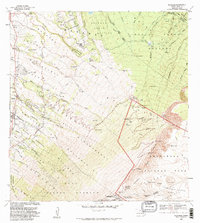
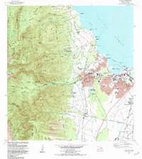 1983 Wailuku1984 Print · USGSMaui's central hub comes to life in the early eighties as the island balanced its industrial roots and growing residential centers. Researchers can trace the layout of Wailuku, locate ancient landmarks like Haleiki Heiau, and find the Battle of Kepaniwai Historical Marker.2 unique versions available
 - 1983 Map of Honolua, 1984 Print
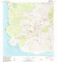
 1983 Honolua1984 Print · USGSHonolulu was a thriving mid-eighties hub of industry and history, from the docks of Iwilei to the heights of St Louis Heights. Genealogists and historians can trace the foundations of the city at Oahu Cem, the Aloha Tower, and the State Capitol.2 unique versions available
 - 1983 Map of Makena, 1984 Print
 1983 Makena1984 Print · USGSMaui's southwestern coast and volcanic uplands are captured here during the early eighties development boom. Researchers can trace land grants in the Kanaio Homesteads, locate the Keawalai Church at Makena, or explore the protected shoreline of La Perouse Bay.
 - 1983 Map of Hana, 1984 Print
 1983 Hana1984 Print · USGSCoastal East Maui during the early eighties shows a landscape of traditional homesteads and developing infrastructure. Genealogists and researchers can trace local landmarks from Hana to Hamoa, including Mokae Landing and the Hana High School.
 - 1983 Map of Haiku, 1984 Print
 1983 Haiku1984 Print · USGSMaui's windward coast and upcountry slopes are captured here in the early eighties, showing the transition from agricultural traditions to modern residential growth. Researchers can locate family sites and landmarks like St Joseph Sch, the Maui Veterans Cemetery, and the Rodeo Arena near Makawao.2 unique versions available
 - 1984 Map of Kahoolawe
 1984 Kahoolawe1984 Print · USGSKahoolawe in the mid-eighties remains dominated by its military role as the Makao District Naval Reservation. Researchers can trace the island's unique topography and coastal landmarks from Lua Makika to Honokanai'a and the Southwest Point Light.
 - 1984 Map of Lanai North
 1984 Lanai North1984 Print · USGSThe northern coast of Lanai in the mid-1980s reveals a landscape of isolated beaches and deep gulches. Researchers can trace the maritime history of Shipwreck Beach and locate the inland settlements of Lanai City and Koele near the island's heart.
 - 1984 Map of Lanai South
 1984 Lanai South1984 Print · USGSSouthern Lanai in the mid-eighties reveals a landscape of high volcanic peaks and ancient coastal sites before modern resort development fully reshaped the shore. Researchers can find cultural landmarks like the Petroglyphs near Kaunolu and the Buddhist Cem near Lanai City.
End of results
Showing maps 1-20 of 20
Top cities of Maui County
- Kahului historical maps
- Wailuku historical maps
- Lahaina historical maps
- Pukalani historical maps
- Kaunakakai historical maps
- Lanai City historical maps
See more
Frequently asked questions
- What are the different types of historical maps available for Maui County?
- What is the oldest map of Maui County?
- Where can I purchase historical maps of Maui County for my home or office?
- Where can I download high-res historical maps of Maui County?
- Are there historical topographic maps available for Maui County?
- Is there historical aerial imagery available for Maui County?
- Where are historical maps of Maui County sourced from?