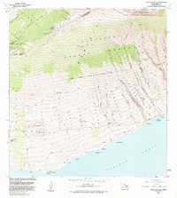
1983 Map of Lualailua Hills
USGS Topo · Published 1983About this map
Haleakala National Park and the vast Kahikinui Forest Reserve dominate this landscape on the southern slopes of Maui, descending from the high volcanic rim of Haleakala Crater down to the rugged Pacific coast. The terrain is marked by a complex network of volcanic features and drainage gulches, including Manawainui and Waiopai. Small, isolated settlements and landmarks such as Hokukano and Kahikinui House are connected by a system of 4WD tracks and historic paths like the Manukani Trail and the Lower Trail. Along the shoreline, the map identifies specific coastal landmarks including Nakaohu Pt and a Natural Arch at Pakowai. This survey illustrates the transition from high-altitude protected forest lands to the arid, lower coastal reaches, reflecting the traditional land divisions and early modern infrastructure of the Makawao and Hana Districts.
Find a feature on this map
37 named features on this map. Tap any name to fly to it.
Don’t see what you’re looking for? This feature index may not catch every label — zoom into the map to look around manually.
Map Details
Editions of this 1983 Lualailua Hills Map
This is the sole edition of this map. No revisions or reprints were ever made.
Other maps of this area

1954 · Maui
USGS Topo · 1:250,000

1954 · Puu O Kali
USGS Topo · 1:24,000

1954 · Makena
USGS Topo · 1:24,000

1957 · Kilohana
USGS Topo · 1:24,000

1957 · Lualailua Hills
USGS Topo · 1:24,000

1957 · Nahiku
USGS Topo · 1:24,000

1957 · Kaupo
USGS Topo · 1:24,000

1966 · Maui
USGS Topo · 1:250,000

1974 · Maui
USGS Topo · 1:250,000

1983 · Nahiku
USGS Topo · 1:24,000