
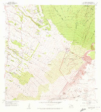
1957 Map of Kilohana
USGS Topo · Published 1959About this map
The dramatic upper slopes of Maui are mapped here just after mid-century, dominated by the immense Haleakala Crater and the protected lands of Haleakala National Park. The landscape is a study in island transition, moving from the dense forest of the Koolau Forest Reserve to the agricultural and residential patterns of the Kula Homesteads and Pulehuiki Homesteads. This period marks the era of early scientific expansion on the mountain, shown by the Haleakala Satellite Tracking Sta Univ of Hawaii Research Site and the Observatory Pakaeao (White Hill).
Find a feature on this map
55 named features on this map. Tap any name to fly to it.
Don’t see what you’re looking for? This feature index may not catch every label — zoom into the map to look around manually.
Map Details
Editions of this 1957 Kilohana Map
2 editions found
Other maps of this area

1954 · Maui
USGS Topo · 1:250,000

1954 · Paia
USGS Topo · 1:24,000

1954 · Puu O Kali
USGS Topo · 1:24,000

1954 · Makena
USGS Topo · 1:24,000

1957 · Haiku
USGS Topo · 1:24,000

1957 · Lualailua Hills
USGS Topo · 1:24,000

1957 · Nahiku
USGS Topo · 1:24,000

1957 · Kaupo
USGS Topo · 1:24,000

1957 · Keanae
USGS Topo · 1:24,000

1966 · Maui
USGS Topo · 1:250,000