
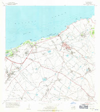
1954 Map of Paia
USGS Topo · Published 1956About this map
The sugar-driven economy of central Maui is on full display in this mid-1950s survey, characterized by a dense network of ethnic and company-assigned worker communities. Puunene and Paia serve as the primary hubs, with the landscape between them dominated by the Sugar Mill and an intricate system of numbered and named clusters like Japanese Village 1, Russian Village, and Alabama Village. This layout provides a clear visual record of the plantation era's social and industrial organization before later suburbanization changed the island's footprint.
Find a feature on this map
73 named features on this map. Tap any name to fly to it.
Don’t see what you’re looking for? This feature index may not catch every label — zoom into the map to look around manually.
Map Details
Editions of this 1954 Paia Map
2 editions found
Other maps of this area

1954 · Maui
USGS Topo · 1:250,000

1954 · Maalaea
USGS Topo · 1:24,000

1954 · Puu O Kali
USGS Topo · 1:24,000

1955 · Wailuku
USGS Topo · 1:24,000

1955 · Kahakuloa
USGS Topo · 1:24,000

1957 · Kilohana
USGS Topo · 1:24,000

1957 · Haiku
USGS Topo · 1:24,000

1966 · Maui
USGS Topo · 1:250,000

1974 · Maui
USGS Topo · 1:250,000
1977 · Paia
USGS Topo · 1:24,000