
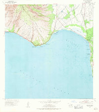
1954 Map of Maalaea
USGS Topo · Published 1956About this map
Maalaea and the surrounding coastline of Maui show a landscape transitioning from the steep ridges of the West Maui Forest Reserve to the agricultural and coastal lowlands. The importance of water management in this environment is evident through the sophisticated network of the Waihee Ditch, Upper Waihee Ditch, and Lower Waihee Ditch, which support the homesteads and fields. Along the shore of Maalaea Bay, the Kealia Pond provides a natural landmark near the Maalaea Small Boat Harbor. To the east, the settlement of Kihei is depicted alongside the Waiohuli-Keokea Homesteads, while aviation history is captured by the presence of both the Old Maui Airport and the Maui Airport (Puunene Airport). This mid-century survey documents the early infrastructure of the Waikapu Homesteads and the emerging coastal developments that would eventually define the region.
Find a feature on this map
61 named features on this map. Tap any name to fly to it.
Don’t see what you’re looking for? This feature index may not catch every label — zoom into the map to look around manually.
Map Details
Editions of this 1954 Maalaea Map
2 editions found
Other maps of this area

1929 · Kahoolawe
USGS Topo · 1:62,500

1954 · Maui
USGS Topo · 1:250,000

1954 · Paia
USGS Topo · 1:24,000

1954 · Puu O Kali
USGS Topo · 1:24,000

1954 · Makena
USGS Topo · 1:24,000

1955 · Olowalu
USGS Topo · 1:24,000

1955 · Wailuku
USGS Topo · 1:24,000

1956 · Lahaina
USGS Topo · 1:24,000

1966 · Maui
USGS Topo · 1:250,000

1974 · Maui
USGS Topo · 1:250,000