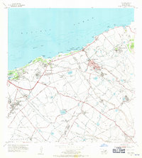
1954 Map of Paia
USGS Topo · Published 1971About this map
The sugarcane industry's complex social and physical infrastructure dominates this coastal region of Maui. A network of labor settlements, many designated by name or number such as Spanish Village and Village 8, surrounds the central Sugar Mill and Puunene operations. This industrial landscape is supported by a sophisticated water management system, including the Lowrie Ditch and Hamakuapoko Ditch, which redirect water across the volcanic slopes to the plantations. Social institutions of the mid-century are well-represented by the Maui Childrens Home, Baldwin Memorial Home, and Maunaolu College. Coastal features like the Kanaha Pond Waterfowl Refuge and Hookipa Park provide a natural contrast to the grid of the Kahului Airport and the numerous railroad lines that once transported cane from the fields to the processing centers. The map also captures the early footprints of coastal communities at Lower Paia and Kuau before modern development.
Find a feature on this map
94 named features on this map. Tap any name to fly to it.
Don’t see what you’re looking for? This feature index may not catch every label — zoom into the map to look around manually.
Map Details
Editions of this 1954 Paia Map
2 editions found
Other maps of this area

1954 · Maui
USGS Topo · 1:250,000

1954 · Maalaea
USGS Topo · 1:24,000

1954 · Paia
USGS Topo · 1:24,000

1954 · Puu O Kali
USGS Topo · 1:24,000

1955 · Wailuku
USGS Topo · 1:24,000

1955 · Kahakuloa
USGS Topo · 1:24,000

1957 · Kilohana
USGS Topo · 1:24,000

1957 · Haiku
USGS Topo · 1:24,000

1966 · Maui
USGS Topo · 1:250,000

1974 · Maui
USGS Topo · 1:250,000