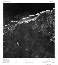
1977 Map of Paia
USGS Topo · Published 1981About this map
Paia and the surrounding coastline of Maui are documented in this orthophotomap through aerial photography captured in late 1976 and early 1977. The imagery reveals the intricate geometry of large-scale agriculture, likely sugarcane, that dominated the landscape between the coastal settlement and the inland areas near Puunene. This specific format combines the geographic precision of a topographic map with the raw visual detail of a photograph, allowing for a clear view of the plantation road networks and the rugged shoreline where the Pacific Ocean meets the north shore. To the east, the map captures the community of Hamakuapoko, providing a detailed look at the island's mid-1970s development before modern expansion shifted the coastal character.
Find a feature on this map
4 named features on this map. Tap any name to fly to it.
Don’t see what you’re looking for? This feature index may not catch every label — zoom into the map to look around manually.
Map Details
Editions of this 1977 Paia Map
This is the sole edition of this map. No revisions or reprints were ever made.
Other maps of this area

1954 · Maui
USGS Topo · 1:250,000

1954 · Maalaea
USGS Topo · 1:24,000

1954 · Paia
USGS Topo · 1:24,000

1954 · Puu O Kali
USGS Topo · 1:24,000

1955 · Wailuku
USGS Topo · 1:24,000

1955 · Kahakuloa
USGS Topo · 1:24,000

1957 · Kilohana
USGS Topo · 1:24,000

1957 · Haiku
USGS Topo · 1:24,000

1966 · Maui
USGS Topo · 1:250,000

1974 · Maui
USGS Topo · 1:250,000