Old Maps of Omaopio, Hawaii for Academic Research
Study the evolution of Omaopio with 9 high-resolution historic maps. Whether you're teaching, researching, or modeling changes in land use, these maps provide essential visual documentation of urban, environmental, and geographic change.
- Analyze long-term change: Track patterns in development, transportation, and natural features.
- Ideal for environmental or urban studies: Support academic projects with primary historical map data.
- Use in the classroom or lab: Educators and researchers rely on these maps to bring historical context to life.
These maps are a powerful tool for teaching, research, and visualizing how Omaopio has changed over the decades.
Omaopio, HI maps
(9)- 1954 Map of Maui
 1954 Maui1954 Print · USGSThe central Hawaiian Islands are shown during the mid-fifties, detailing the agricultural and coastal infrastructure of Maui, Lanai, and Molokai. Genealogists and researchers can trace plantation-era history at Haliimaile Camp, locate old harbors like Kaumalapau Harbor, or explore the early bounds of Haleakala National Park.
 - 1957 Map of Kilohana, 1959 Print
 1957 Kilohana1959 Print · USGSMaui in the late fifties reveals a high-altitude landscape of homesteads and early scientific research on the slopes of the mountain. Trace the development of the Kula Homesteads and find historic sites like the Olinda Prison Camp or the Silversword Inn.2 unique versions available
 - 1966 Map of Maui
 1966 Maui1966 Print · USGSThe central islands of Maui, Molokai, Lanai, and Kahoolawe are shown in detail during the mid-1960s as plantation life and early tourism coexisted. Genealogists and researchers can trace family locations in old plantation towns like Puunene, the harbor at Lahaina, and Hoolehua on Molokai.
 - 1974 Map of Maui
 1974 Maui1974 Print · USGSMid-century Hawaii is captured here through the detailed landscapes of Maui, Molokai, Lanai, and Kahoolawe as they appeared in the 1970s. Researchers can trace the layout of island hubs like Lahaina and Lanai City alongside remote landmarks like Wainapanapa Cave.2 unique versions available
 - 1983 Map of Kilohana
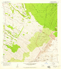
 1983 Kilohana1983 Print · USGSUpcountry Maui in the early eighties shows a unique blend of agricultural homesteads and the volcanic heights of the summit. Genealogists and hikers can trace the Haleakala Homesteads and find landmarks like Waiakoa or the Holua Cabin trail shelter.2 unique versions available
 - 1991 Map of Kilohana, 2003 Print
 1991 Kilohana2003 Print · USGSThe high slopes of Maui are captured here during the early 1990s, where the volcanic interior meets agricultural homesteads. Researchers can trace the layout of the Haleakala Homesteads and find landmarks like the Olinda State Facility and Ukulele Camp (Site).
 - 2013 Map of Kilohana, 2013 Print
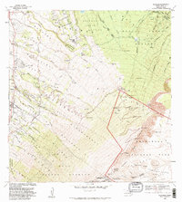
 2013 Kilohana2013 Print · USGSCovers Omaopio, including Waiakoa, Kula, and other nearby areas
 - 2017 Map of Kilohana, 2017 Print
 2017 Kilohana2017 Print · USGSCovers Omaopio, including Waiakoa, Kula, and other nearby areas
 - 2024 Map of Kilohana, 2024 Print
 2024 Kilohana2024 Print · USGSUpcountry Maui in the modern era reveals a landscape of high-elevation ranching and residential growth on the slopes of Haleakalā. Trace the local landmarks of Kula and Pūlehu, or locate the historic Holy Ghost Church Catholic and its Cem.
End of results
Showing maps 1-9 of 9
Top cities near Omaopio
Frequently asked questions
- What are the different types of historical maps available for Omaopio?
- What is the oldest map of Omaopio?
- Where can I purchase historical maps of Omaopio for my home or office?
- Where can I download high-res historical maps of Omaopio?
- Are there historical topographic maps available for Omaopio?
- Is there historical aerial imagery available for Omaopio?
- Where are historical maps of Omaopio sourced from?