1950s Maps of Peahi, Maui County
Explore 2 historic maps of Peahi from the 1950s. These maps offer a rare glimpse into what life looked like during the 1950s — showing old roads, neighborhoods, homes, and landmarks that have changed or disappeared over time.
Whether you're researching your family's past, planning a metal detecting trip, or studying how Peahi's landscape evolved across the 1950s, these high-resolution maps are a powerful tool for exploring the history of this region.
- Focus on a specific era: All maps on this page are from the 1950s, giving you a focused view of this time period.
- See what’s changed: Compare century-old streets, trails, and buildings to today's modern landscape using overlays and satellite layers.
- Research with precision: Use these maps for genealogy, historical research, land use analysis, or educational projects.
- View, download, or print: Maps are fully viewable online in high resolution, and can be downloaded or printed for your own records.
Start exploring Peahi's history through authentic maps from the 1950s. This is your window into the past.
Peahi, Maui County maps
(2)- 1954 Map of Maui
 1954 Maui1954 Print · USGSThe central Hawaiian Islands are shown during the mid-fifties, detailing the agricultural and coastal infrastructure of Maui, Lanai, and Molokai. Genealogists and researchers can trace plantation-era history at Haliimaile Camp, locate old harbors like Kaumalapau Harbor, or explore the early bounds of Haleakala National Park.
 - 1957 Map of Haiku, 1959 Print
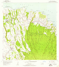 1957 Haiku1959 Print · USGSCoastal Maui in the late fifties shows a landscape shaped by sugar plantation infrastructure and small rural communities. Genealogists and historians can trace worker settlements like Filipino Camp, locate the Haiku School, and follow the old Hana Highway corridor.3 unique versions available
End of results
Showing maps 1-2 of 2
Frequently asked questions
- What are the different types of historical maps available for Peahi?
- What is the oldest map of Peahi?
- Where can I purchase historical maps of Peahi for my home or office?
- Where can I download high-res historical maps of Peahi?
- Are there historical topographic maps available for Peahi?
- Is there historical aerial imagery available for Peahi?
- Where are historical maps of Peahi sourced from?