Old Maps of Pukaʻauhuhu, Hawaii for Genealogy
Trace your family roots with 9 historic maps of Pukaʻauhuhu. These high-res maps reveal old neighborhoods, homesites, landmarks, and streets — helping you uncover where your ancestors lived and how the area evolved over time.
- Explore historic neighborhoods: Identify where your relatives may have lived in the 1800s or 1900s.
- Compare maps over time: Trace the changes in streets, buildings, and landmarks for multi-generational research.
- Perfect for genealogy & ancestry research: Used by family historians and researchers to map out lineage and migration.
These maps are an incredible resource for exploring your personal connection to Pukaʻauhuhu's past.
Pukaʻauhuhu, HI maps
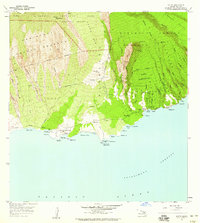
(9)- 1954 Map of Maui
 1954 Maui1954 Print · USGSThe central Hawaiian Islands are shown during the mid-fifties, detailing the agricultural and coastal infrastructure of Maui, Lanai, and Molokai. Genealogists and researchers can trace plantation-era history at Haliimaile Camp, locate old harbors like Kaumalapau Harbor, or explore the early bounds of Haleakala National Park.
 - 1957 Map of Kaupo, 1959 Print
 1957 Kaupo1959 Print · USGSThe remote southern coast of Maui is captured in the late fifties as a landscape of traditional homesteads and ancient Hawaiian sites. Genealogists and historians can trace the Kaupo Homesteads and locate significant landmarks like Loaloa Heiau and the Nuu (Site).2 unique versions available
 - 1966 Map of Maui
 1966 Maui1966 Print · USGSThe central islands of Maui, Molokai, Lanai, and Kahoolawe are shown in detail during the mid-1960s as plantation life and early tourism coexisted. Genealogists and researchers can trace family locations in old plantation towns like Puunene, the harbor at Lahaina, and Hoolehua on Molokai.
 - 1974 Map of Maui
 1974 Maui1974 Print · USGSMid-century Hawaii is captured here through the detailed landscapes of Maui, Molokai, Lanai, and Kahoolawe as they appeared in the 1970s. Researchers can trace the layout of island hubs like Lahaina and Lanai City alongside remote landmarks like Wainapanapa Cave.2 unique versions available
 - 1983 Map of Kaupo
 1983 Kaupo1983 Print · USGSThe southern coast of Maui is captured here in the early eighties, showcasing a landscape defined by volcanic slopes and ancient Hawaiian sites. Researchers can trace land divisions at Kaupo Homesteads or locate cultural landmarks like Loaloa Heiau and the Nuu (Site).
 - 1996 Map of Kaupo, 1999 Print
 1996 Kaupo1999 Print · USGSThe southern slopes of Maui meet the Alenuihaha Channel in the late twentieth century, showing a landscape defined by traditional homesteads and national park boundaries. Genealogists and local historians can locate Kaupo Homesteads, the historic Nuu (Site), and coastal landmarks like Mokulau Landing.
 - 2013 Map of Kaupo, 2013 Print
 2013 Kaupo2013 Print · USGSCovers Pukaʻauhuhu, including Kaupō, Puka‘au‘huhu, and other nearby areas
 - 2017 Map of Kaupo, 2017 Print
 2017 Kaupo2017 Print · USGSCovers Pukaʻauhuhu, including Kaupō, Puka‘au‘huhu, and other nearby areas
 - 2024 Map of Kaupo, 2024 Print
 2024 Kaupo2024 Print · USGSThe southern slopes of Maui come alive in this survey of the descent from the volcanic heights to the sea. Modern researchers can trace the historic Kaupo Trl through the Kaupo Gap or locate coastal settlements like Pōhakuloa and Mokulau.
End of results
Showing maps 1-9 of 9
Top cities near Pukaʻauhuhu
Frequently asked questions
- What are the different types of historical maps available for Pukaʻauhuhu?
- What is the oldest map of Pukaʻauhuhu?
- Where can I purchase historical maps of Pukaʻauhuhu for my home or office?
- Where can I download high-res historical maps of Pukaʻauhuhu?
- Are there historical topographic maps available for Pukaʻauhuhu?
- Is there historical aerial imagery available for Pukaʻauhuhu?
- Where are historical maps of Pukaʻauhuhu sourced from?