1910s Maps of Heipa District
Explore 3 historic maps of Heipa District from the 1910s. These maps offer a rare glimpse into what life looked like during the 1910s — showing old roads, neighborhoods, homes, and landmarks that have changed or disappeared over time.
Whether you're researching your family's past, planning a metal detecting trip, or studying how Heipa District's landscape evolved across the 1910s, these high-resolution maps are a powerful tool for exploring the history of this region.
- Focus on a specific era: All maps on this page are from the 1910s, giving you a focused view of this time period.
- See what’s changed: Compare century-old streets, trails, and buildings to today's modern landscape using overlays and satellite layers.
- Research with precision: Use these maps for genealogy, historical research, land use analysis, or educational projects.
- View, download, or print: Maps are fully viewable online in high resolution, and can be downloaded or printed for your own records.
Start exploring Heipa District's history through authentic maps from the 1910s. This is your window into the past.
Heipa District maps
(3)- 1916 Map of Peever, 1954 Print
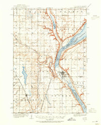 1916 Peever1954 Print · USGSThe borderlands of South Dakota and Minnesota come alive in this survey of the early twentieth century. Genealogists and local historians can trace the paths of the Great Northern railroad and locate rural landmarks like Windom School, Peever, and the Erdman School.
 - 1917 Map of New Effington
 1917 New Effington1917 Print · USGSThe Dakota borderlands come alive in this survey from the mid-1910s, capturing the early rail-and-reservation era. Genealogists can locate family-named landmarks like Shafts School and Wymen School along the Minneapolis St Paul and Sault Ste Marie line.2 unique versions available
 - 1918 Map of Peever
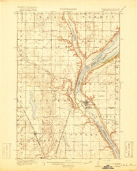 1918 Peever1918 Print · USGSThe borderlands of South Dakota and Minnesota are captured here during the First World War, centered on the strategic divide at Browns Valley. Genealogists and local historians can trace rural school locations like Morehead School and Becker School alongside the tracks of the Great Northern railroad.4 unique versions available
End of results
Showing maps 1-3 of 3
Top cities near Heipa District
- Sisseton historical maps
- Lidgerwood historical maps
- Long Hollow historical maps
- Veblen historical maps
- Claire City historical maps
- Cayuga historical maps
Top neighborhoods of Heipa District
- Marboe Township historical maps
- Hammer historical maps
- Dahlberg historical maps
- Hillhead historical maps
- Tewaukon Township historical maps
- Marlow historical maps
See more
Frequently asked questions
- What are the different types of historical maps available for Heipa District?
- What is the oldest map of Heipa District?
- Where can I purchase historical maps of Heipa District for my home or office?
- Where can I download high-res historical maps of Heipa District?
- Are there historical topographic maps available for Heipa District?
- Is there historical aerial imagery available for Heipa District?
- Where are historical maps of Heipa District sourced from?