1970s Maps of Benewah County, Idaho
Explore 2 historic maps of Benewah County from the 1970s. These maps offer a rare glimpse into what life looked like during the 1970s — showing old roads, neighborhoods, homes, and landmarks that have changed or disappeared over time.
Whether you're researching your family's past, planning a metal detecting trip, or studying how Benewah County's landscape evolved across the 1970s, these high-resolution maps are a powerful tool for exploring the history of this region.
- Focus on a specific era: All maps on this page are from the 1970s, giving you a focused view of this time period.
- See what’s changed: Compare century-old streets, trails, and buildings to today's modern landscape using overlays and satellite layers.
- Research with precision: Use these maps for genealogy, historical research, land use analysis, or educational projects.
- View, download, or print: Maps are fully viewable online in high resolution, and can be downloaded or printed for your own records.
Start exploring Benewah County's history through authentic maps from the 1970s. This is your window into the past.
Benewah County, ID maps
(2)- 1975 Map of Plummer SE, 1977 Print
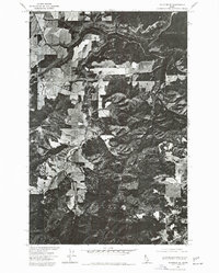 1975 Plummer SE1977 Print · USGSBenewah County lands are captured in this mid-seventies aerial perspective, showing the intersection of reservation timberlands and local waterways. Researchers can trace the drainage of Benewah Creek or locate landmarks like Plummer Butte.
 - 1975 Map of Plummer NE, 1977 Print
 1975 Plummer NE1977 Print · USGSHarrison and the surrounding shores of Kootenai County are seen here in the mid-seventies just as the landscape was transitioning through new agricultural and tribal land management. Researchers can trace the exact shoreline of Coeur d'Alene Lake and the mouth of the Coeur d'Alene River near Harrison.
End of results
Showing maps 1-2 of 2
Top cities of Benewah County
Frequently asked questions
- What are the different types of historical maps available for Benewah County?
- What is the oldest map of Benewah County?
- Where can I purchase historical maps of Benewah County for my home or office?
- Where can I download high-res historical maps of Benewah County?
- Are there historical topographic maps available for Benewah County?
- Is there historical aerial imagery available for Benewah County?
- Where are historical maps of Benewah County sourced from?